
Kochi Prefecture topographic map
Interactive map
Click on the map to display elevation.
About this map
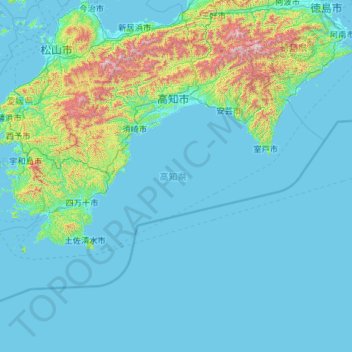
Name: Kochi Prefecture topographic map, elevation, terrain.
Location: Kochi Prefecture, Japan (32.38446 132.21266 33.88336 134.54238)
Average elevation: 155 m
Minimum elevation: -2 m
Maximum elevation: 1,883 m
Kōchi Prefecture comprises the southwestern part of the island of Shikoku, facing the Pacific Ocean. It is bordered by Ehime to the north-west and Tokushima to the north-east. It is the largest but least populous of Shikoku's four prefectures. Most of the province is mountainous, and in only a few areas such as around Kōchi and Nakamura is there a coastal plain. Kōchi is famous for its many rivers. Inamura-yama in Tosa-cho is the highest peak in Kōchi prefecture with an altitude of 1,506 meters above sea level.
Other topographic maps
Click on a map to view its topography, its elevation and its terrain.
Okinawa Prefecture
Japan > Kyushu Region > Nago
Okinawa Prefecture, 県道18号, Nago, Okinawa Prefecture, Kyushu Region, 905-2266, Japan
Average elevation: 139 m
Hokkaido
Japan > Hokkaidō Region > Ashoro
Hokkaido, Ashoro, Tokachi Subprefecture, Hokkaidō Prefecture, Hokkaidō Region, Japan
Average elevation: 98 m
Kyoto
Japan > Kinki Region > Kyoto
Minami Ward, Kyoto, Kyoto Prefecture, Kinki Region, Japan
Average elevation: 22 m
Mount Fuji
Japan > Sunto County > Oyama
Mount Fuji, Oyama, Sunto County, Shizuoka Prefecture, Japan
Average elevation: 3,261 m
Nachi Falls
Japan > Higashimuro County > Nachikatsuura
Nachi Falls, Nachikatsuura, Higashimuro County, Wakayama Prefecture, Japan
Average elevation: 446 m
Akashima Island
Akashima Island, Koda, Sado, Niigata Prefecture, Japan
Average elevation: 26 m
Izu Peninsula
Japan > Chubu Region > Izu
Izu Peninsula, 伊東西伊豆線, Izu, Shizuoka Prefecture, Chubu Region, 410-2516, Japan
Average elevation: 132 m
Hokkaido
Japan > Hokkaidō Region > Shintoku
Hokkaido, トノカリ2の沢支線林道, Shintoku, Kamikawa, Tokachi Subprefecture, Hokkaidō Prefecture, Hokkaidō Region, Japan
Average elevation: 826 m
Kyoto Prefecture
Japan > Kinki Region > Kyotanba
Kyoto Prefecture, 綾部宮島線, Kyotanba, Funai County, Kyoto Prefecture, Kinki Region, Japan
Average elevation: 453 m
Karuizawa
Japan > Chubu Region > Karuizawa
Karuizawa, Kitasaku County, Nagano Prefecture, Chubu Region, 389-0102, Japan
Average elevation: 1,018 m