
Lake Tanganyika topographic map
Interactive map
Click on the map to display elevation.
About this map
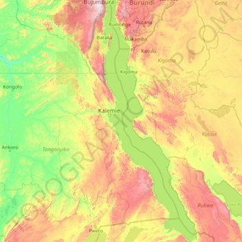
Name: Lake Tanganyika topographic map, elevation, terrain.
Location: Lake Tanganyika, Democratic Republic of the Congo (-8.81112 29.05797 -3.34678 31.20210)
Average elevation: 1,064 m
Minimum elevation: 483 m
Maximum elevation: 3,224 m
Other topographic maps
Click on a map to view its topography, its elevation and its terrain.
Kindu
Democratic Republic of the Congo > Maniema > Kindu
Kindu, Maniema, 00000, Democratic Republic of the Congo
Average elevation: 530 m
Tanganyika
Democratic Republic of the Congo
Tanganyika, Democratic Republic of the Congo
Average elevation: 1,039 m
Tshopo
Democratic Republic of the Congo > Tshopo
Tshopo, Democratic Republic of the Congo
Average elevation: 529 m
Yangambi
Democratic Republic of the Congo > Tshopo > Yangambi
Yangambi, Tshopo, Democratic Republic of the Congo
Average elevation: 409 m