
Jotunheimen topographic map
Interactive map
Click on the map to display elevation.
About this map
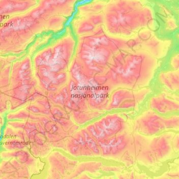
Name: Jotunheimen topographic map, elevation, terrain.
Location: Jotunheimen, Lom, Oppland, Norway (61.37689 7.73871 61.73402 8.85344)
Average elevation: 1,396 m
Minimum elevation: 469 m
Maximum elevation: 2,457 m
Other topographic maps
Click on a map to view its topography, its elevation and its terrain.
Vetle Skagastølstind
Vetle Skagastølstind, Luster, Sogn og Fjordane, Norway
Average elevation: 1,783 m
Jesus Lever-steinen
Jesus Lever-steinen, Løvstien, Solheims Boretslag, Solheim, Årstad, Gyldenpris, Bergen, Hordaland, 5057, Norway
Average elevation: 100 m