
Ann Arbor topographic map
Interactive map
Click on the map to display elevation.
About this map
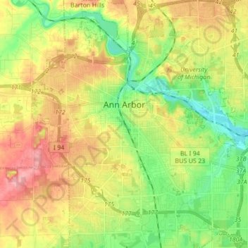
Name: Ann Arbor topographic map, elevation, terrain.
Average elevation: 268 m
Minimum elevation: 224 m
Maximum elevation: 326 m
According to the United States Census Bureau, the city has a total area of 28.70 square miles (74.33 km2), of which, 27.83 square miles (72.08 km2) of it is land and 0.87 square miles (2.25 km2) is water, much of which is part of the Huron River. Ann Arbor is about 35 miles (56 km) west of Detroit. Ann Arbor Charter Township adjoins the city's north and east sides. Ann Arbor is situated on the Huron River in a productive agricultural and fruit-growing region. The landscape of Ann Arbor consists of hills and valleys, with the terrain becoming steeper near the Huron River. The elevation ranges from about 750 feet (230 m) along the Huron River to 1,015 feet (309 m) on the city's west side, near the intersection of Maple Road and Pauline Blvd. Generally, the west-central and northwestern parts of the city and U-M's North Campus are the highest parts of the city; the lowest parts are along the Huron River and in the southeast. Ann Arbor Municipal Airport, which is south of the city at 42°13.38′N 83°44.74′W / 42.22300°N 83.74567°W / 42.22300; -83.74567, has an elevation of 839 feet (256 m).