
Thank you for supporting this site ❤️
Make a donation
Make a donation
Saint Cloud topographic map
Click on the map to display elevation.
Thank you for supporting this site ❤️
Make a donation
Make a donation
About this map
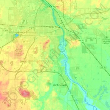
Name: Saint Cloud topographic map, elevation, terrain.
Location: Saint Cloud, Stearns County, Minnesota, United States (45.45248 -94.26341 45.59047 -94.03580)
Average elevation: 319 m
Minimum elevation: 286 m
Maximum elevation: 367 m
Thank you for supporting this site ❤️
Make a donation
Make a donation
Other topographic maps
Click on a map to view its topography, its elevation and its terrain.
Pearl Lake
United States > Minnesota > Stearns County > Maine Prairie Township
Average elevation: 343 m