
Municipality of Debar topographic map
Interactive map
Click on the map to display elevation.
About this map
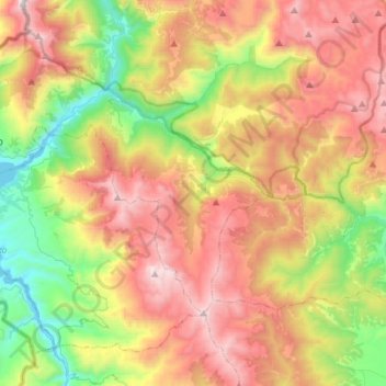
Name: Municipality of Debar topographic map, elevation, terrain.
Location: Municipality of Debar, Southwestern Region, 1250, Macedonia (41.40849 20.45290 41.58198 20.72970)
Average elevation: 1,369 m
Minimum elevation: 568 m
Maximum elevation: 2,316 m
Other topographic maps
Click on a map to view its topography, its elevation and its terrain.
Municipality of Ohrid
Macedonia > Southwestern Region
Municipality of Ohrid, Southwestern Region, Macedonia
Average elevation: 988 m
Lake Ohrid
Macedonia > Southwestern Region
Lake Ohrid, Municipality of Ohrid, Southwestern Region, 6330, Macedonia
Average elevation: 959 m
Debar
Macedonia > Southwestern Region > Debar
Debar, Municipality of Debar, Southwestern Region, 1250, Macedonia
Average elevation: 725 m
Ohrid
Macedonia > Southwestern Region > Ohrid
Ohrid, Municipality of Ohrid, Southwestern Region, Macedonia
Average elevation: 773 m
Стогово
Macedonia > Southwestern Region > Broshtica
Стогово, Broshtica, Municipality of Centar Zhupa, Southwestern Region, Macedonia
Average elevation: 1,882 m