
Madison County topographic map
Interactive map
Click on the map to display elevation.
About this map
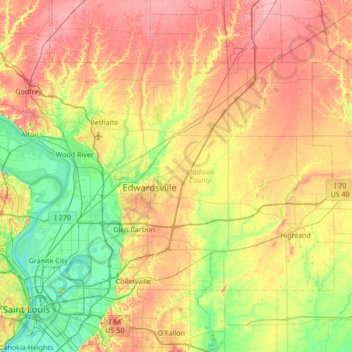
Name: Madison County topographic map, elevation, terrain.
Location: Madison County, Illinois, United States (38.65590 -90.27581 39.00022 -89.59673)
Average elevation: 161 m
Minimum elevation: 119 m
Maximum elevation: 212 m
Other topographic maps
Click on a map to view its topography, its elevation and its terrain.
Cornell
United States > Illinois > Livingston County
Cornell, Amity Township, Livingston County, Illinois, United States
Average elevation: 193 m
Glencoe
United States > Illinois > Cook County
Glencoe, New Trier Township, Cook County, Illinois, 60022, United States
Average elevation: 194 m
Alton
United States > Illinois > Alton
Alton, Madison County, Illinois, 62002, United States
Average elevation: 150 m