
Lake Meredith topographic map
Interactive map
Click on the map to display elevation.
About this map
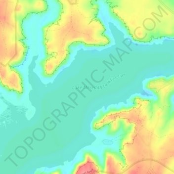
Name: Lake Meredith topographic map, elevation, terrain.
Location: Lake Meredith, Hutchinson County, Texas, United States (35.69171 -101.59735 35.71992 -101.55094)
Average elevation: 906 m
Minimum elevation: 878 m
Maximum elevation: 957 m
Other topographic maps
Click on a map to view its topography, its elevation and its terrain.
Fritch
United States > Texas > Hutchinson County
Fritch, Hutchinson County, Texas, United States
Average elevation: 965 m
Phillips
United States > Texas > Hutchinson County
Phillips, Hutchinson County, Texas, 79007, United States
Average elevation: 905 m
Stinnett
United States > Texas > Hutchinson County
Stinnett, Hutchinson County, Texas, United States
Average elevation: 977 m
Borger
United States > Texas > Hutchinson County
Borger, Hutchinson County, Texas, 79007, United States
Average elevation: 929 m