
Make a donation
Bosham topographic map
Click on the map to display elevation.
Make a donation
About this map
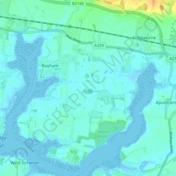
Name: Bosham topographic map, elevation, terrain.
Location: Bosham, Chichester, West Sussex, England, United Kingdom (50.80212 -0.87348 50.84997 -0.81344)
Average elevation: 5 m
Minimum elevation: -3 m
Maximum elevation: 35 m
Make a donation
Other topographic maps
Click on a map to view its topography, its elevation and its terrain.
Make a donation
Make a donation
Make a donation
Make a donation
Make a donation
Make a donation
Make a donation
Make a donation
Make a donation
Make a donation
Horncroft Common Plantation
United Kingdom > England > West Sussex > Chichester
Average elevation: 22 m
Make a donation
Blackdown
United Kingdom > England > West Sussex > Chichester
Blackdown, or Black Down, summit elevation 279.7 metres (918 ft) AMSL, is the highest point in both the historic county of Sussex and the South Downs National Park. It is one of the highest points in the south east of England, exceeded by Walbury Hill, Leith Hill and Pilot Hill. Blackdown is protected as part…
Average elevation: 165 m