
San Andrés Cholula topographic map
Interactive map
Click on the map to display elevation.
About this map
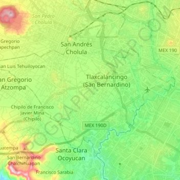
Name: San Andrés Cholula topographic map, elevation, terrain.
Location: San Andrés Cholula, Puebla, Mexico (18.97565 -98.35819 19.06850 -98.22386)
Average elevation: 2,136 m
Minimum elevation: 2,010 m
Maximum elevation: 2,378 m
Other topographic maps
Click on a map to view its topography, its elevation and its terrain.
Iztaccíhuatl
Mexico > Puebla > San Salvador el Verde
The name "Iztaccíhuatl" is Nahuatl for "White (like salt) woman", reflecting the four individual snow-capped peaks which depict the head, chest, knees and feet of a sleeping female when seen from east or west. Iztaccíhuatl is to the north of its twin Popocatépetl, to which it is connected by the high…
Average elevation: 4,732 m
San Antonio Cacalotepec
Mexico > Puebla > San Andrés Cholula > San Bernardino Tlaxcalancingo
Average elevation: 2,113 m
Puebla City
Mexico > Puebla > Municipio de Puebla
Most of its mountains belong to the Sierra Madre Oriental and the Trans-Mexican Volcanic Belt. The first is locally called the Sierra Norte del Puebla, entering the state from the northwest and then breaks up into the smaller chains of Sierra de Zacapoaxtla, Sierra de Huauchinango, Sierra de Teziutlán, Sierra…
Average elevation: 2,233 m
Pico de Orizaba
Mexico > Puebla > Chalchicomula de Sesma
Pico de Orizaba, also known as Citlaltépetl (from Nahuatl citlal(in) = star, and tepētl = mountain), is an active volcano, the highest mountain in Mexico and third highest in North America, after Denali of United States and Mount Logan of Canada. Pico de Orizaba is also the highest volcano in North America.…
Average elevation: 4,969 m
Pico de Orizaba
Mexico > Puebla > Chalchicomula de Sesma
Pico de Orizaba, also known as Citlaltépetl (from Nahuatl citlal(in) = star, and tepētl = mountain), is an active stratovolcano, the highest mountain in Mexico and third highest in North America, after Denali of United States and Mount Logan of Canada. Pico de Orizaba is also the highest volcano in North…
Average elevation: 4,969 m
Bosques de Amalucan Segunda Sección
Mexico > Puebla > Bosques de Amalucan Segunda Sección
Average elevation: 2,265 m
Cholula de Rivadavia
Mexico > Puebla > San Pedro Cholula > Cholula de Rivadavia
Average elevation: 2,155 m