
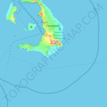
Thira Municipal Unit topographic map
Interactive map
Click on the map to display elevation.
About this map
Name: Thira Municipal Unit topographic map, elevation, terrain.
Average elevation: 12 m
Minimum elevation: -1 m
Maximum elevation: 552 m
Other topographic maps
Click on a map to view its topography, its elevation and its terrain.
Emporio
Greece > Aegean > Thira Regional Unit > Thira Municipal Unit > Emporio
Emporio, Thira Municipal Unit, Municipality of Thira, Thira Regional Unit, South Aegean, Aegean, 84703, Greece
Average elevation: 116 m