
Mut topographic map
Interactive map
Click on the map to display elevation.
About this map
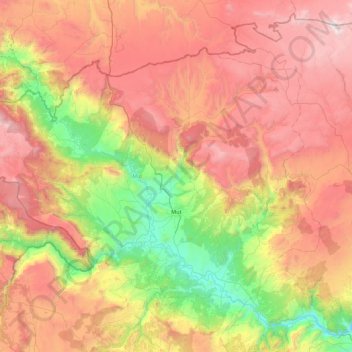
Name: Mut topographic map, elevation, terrain.
Location: Mut, Mersin, Mediterranean Region, 33600, Turkey (36.45912 32.94780 36.95287 33.79750)
Average elevation: 1,132 m
Minimum elevation: 39 m
Maximum elevation: 2,229 m
Other topographic maps
Click on a map to view its topography, its elevation and its terrain.
Sertavul Yaylası
Turkey > Mut > Sertavul Yaylası
Sertavul Yaylası, Mut, Mersin, Mediterranean Region, Turkey
Average elevation: 1,560 m