
Paal topographic map
Interactive map
Click on the map to display elevation.
About this map
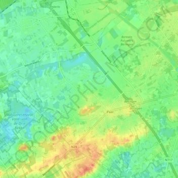
Name: Paal topographic map, elevation, terrain.
Location: Paal, Beringen, Hasselt, Limburg, 3583, België (51.01637 5.12153 51.07875 5.21185)
Average elevation: 31 m
Minimum elevation: 13 m
Maximum elevation: 58 m
Ook ten zuiden van de kom van Paal ligt een reeks getuigenheuvels tot 50 meter hoogte, die de rechteroever van de Zwarte Beek omzomen.
Other topographic maps
Click on a map to view its topography, its elevation and its terrain.
Beringen-Mijn
België > Limburg > Hasselt > Beringen
Beringen-Mijn, Koersel, Beringen, Hasselt, Limburg, 3582, België
Average elevation: 36 m