
Oldenzaal topographic map
Interactive map
Click on the map to display elevation.
About this map
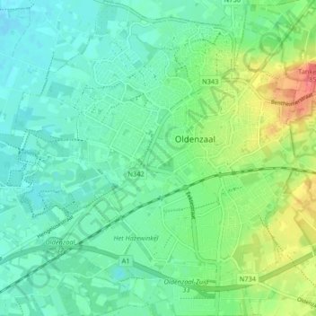
Name: Oldenzaal topographic map, elevation, terrain.
Location: Oldenzaal, Overijssel, Nederland (52.28366 6.87734 52.33346 6.95039)
Average elevation: 40 m
Minimum elevation: 21 m
Maximum elevation: 86 m
Other topographic maps
Click on a map to view its topography, its elevation and its terrain.
Deurningen
Nederland > Overijssel > Oldenzaal
Deurningen, Oldenzaal, Overijssel, Nederland
Average elevation: 30 m