
Noord-Brabant topographic map
Interactive map
Click on the map to display elevation.
About this map
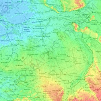
Name: Noord-Brabant topographic map, elevation, terrain.
Location: Noord-Brabant, Nederland (51.22091 4.19012 51.83075 6.04812)
Average elevation: 22 m
Minimum elevation: -7 m
Maximum elevation: 158 m
Other topographic maps
Click on a map to view its topography, its elevation and its terrain.
Wageningen
Nederland > Gelderland > Wageningen
Wageningen, Gelderland, Nederland
Average elevation: 14 m
Utrechtse Heuvelrug
Utrechtse Heuvelrug, Utrecht, Nederland
Average elevation: 10 m
Twente
Nederland > Overijssel > Saasveld
Twente, Saasveld, Dinkelland, Overijssel, Nederland, 7597 KL, Nederland
Average elevation: 36 m
Naarden
Naarden, Gooise Meren, Noord-Holland, Nederland
Average elevation: 2 m
Nootdorp
Nootdorp, Pijnacker-Nootdorp, Zuid-Holland, Nederland
Average elevation: -2 m
Blaricum
Nederland > Noord-Holland > Blaricum
Blaricum, Noord-Holland, Nederland
Average elevation: 0 m