
The Bahamas topographic map
Interactive map
Click on the map to display elevation.
About this map
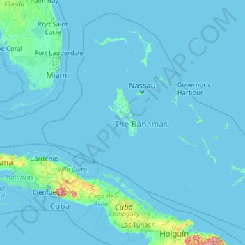
Name: The Bahamas topographic map, elevation, terrain.
Location: The Bahamas (20.70598 -80.70019 27.47346 -72.44775)
Average elevation: 9 m
Minimum elevation: -4 m
Maximum elevation: 1,111 m
The climate of the Bahamas is mostly tropical savannah climate or Aw according to Köppen climate classification. The low latitude, warm tropical Gulf Stream, and low elevation give the Bahamas a warm and winterless climate. Although every few decades low temperatures can fall below 10 °C (50 °F) for a few hours when a severe cold outbreak comes off the North American mainland, there is only a 7 °C difference between the warmest month and coolest month in most of the Bahama islands. As with most tropical climates, seasonal rainfall follows the sun, and summer is the wettest season. The Bahamas have been free of snowfall, with the exception of a report of snow mixed with rain reported in Freeport on the island of Grand Bahama on 19 January 1977. The Bahamas are often sunny and dry for long periods of time, and average more than 3,000 hours or 340 days of sunlight annually.
Other topographic maps
Click on a map to view its topography, its elevation and its terrain.
Paradise Island
Paradise Island, Nassau, New Providence, The Bahamas
Average elevation: 3 m
Elbow Cay
The Bahamas > Hope Town > North End
Elbow Cay, North End, Hope Town, The Bahamas
Average elevation: 1 m
Crooked Island
The Bahamas > Crooked Island and Long Cay
Crooked Island, Crooked Island and Long Cay, The Bahamas
Average elevation: 0 m
Coconut Grove
Coconut Grove, New Providence, The Bahamas
Average elevation: 8 m
Grand Bahama
The Bahamas > East Grand Bahama
Grand Bahama, East Grand Bahama, The Bahamas
Average elevation: 1 m