
Steyl topographic map
Interactive map
Click on the map to display elevation.
About this map
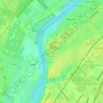
Name: Steyl topographic map, elevation, terrain.
Location: Steyl, Venlo, Limburg, Nederland (51.32680 6.11640 51.34337 6.13514)
Average elevation: 21 m
Minimum elevation: 11 m
Maximum elevation: 30 m
Steyl (Tegels: Sjteil; op de topografische kaart: Steijl) is een dorp in de gemeente Venlo (stadsdeel Tegelen) in de Nederlandse provincie Limburg. Het dorp aan de Maas is vooral bekend als kloosterdorp. Sinds 2004 geniet een deel van de oude dorpskern bescherming van rijkswege als beschermd dorpsgezicht Steyl.