
Vietnam topographic map
Interactive map
Click on the map to display elevation.
About this map
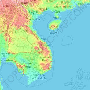
Name: Vietnam topographic map, elevation, terrain.
Location: Vietnam (7.69209 102.14386 23.39269 114.85726)
Average elevation: 173 m
Minimum elevation: -3 m
Maximum elevation: 2,808 m
Due to differences in latitude and the marked variety in topographical relief, Vietnam's climate tends to vary considerably for each region. During the winter or dry season, extending roughly from November to April, the monsoon winds usually blow from the northeast along the Chinese coast and across the Gulf of Tonkin, picking up considerable moisture. The average annual temperature is generally higher in the plains than in the mountains, especially in southern Vietnam compared to the north. Temperatures vary less in the southern plains around Ho Chi Minh City and the Mekong Delta, ranging from between 21 and 35 °C (69.8 and 95.0 °F) over the year. In Hanoi and the surrounding areas of Red River Delta, the temperatures are much lower between 15 and 33 °C (59.0 and 91.4 °F). Seasonal variations in the mountains, plateaus, and the northernmost areas are much more dramatic, with temperatures varying from 3 °C (37.4 °F) in December and January to 37 °C (98.6 °F) in July and August. Vietnam receives high rates of precipitation in the form of rainfall with an average amount from 1,500 mm (59 in) to 2,000 mm (79 in) during the monsoon seasons; this often causes flooding, especially in the cities with poor drainage systems. The country is also affected by tropical depressions, tropical storms and typhoons. Vietnam is one of the world's countries most vulnerable to climate change, with 55% of its population living in low-elevation coastal areas.
Other topographic maps
Click on a map to view its topography, its elevation and its terrain.
Chasiv Yar
Chasiv Yar, Chasiv Yar urban hromada, Bakhmut Raion, Donetsk Oblast, 84551-84556, Ukraine
Average elevation: 213 m
Okinawa Prefecture
Japan > Kyushu Region > Nago
Okinawa Prefecture, 県道18号, Nago, Okinawa Prefecture, Kyushu Region, 905-2266, Japan
Average elevation: 139 m
Hillsboro
United States > Oregon > Washington County
Hillsboro, Washington County, Oregon, United States
Average elevation: 53 m
Greater Brisbane
Greater Brisbane, City of Moreton Bay, Queensland, Australia
Average elevation: 87 m
Kurgan
Russia > Kurgan Oblast > Kurgan
Kurgan, Kurgan Oblast, Ural Federal District, Russia
Average elevation: 96 m
Avdiivka
Avdiivka, Avdiivka urban hromada, Pokrovskii Raion, Donetsk Oblast, 86060-86075, Ukraine
Average elevation: 206 m
Russia
Russia
Average elevation: 150 m
Fehmarn
Germany > Schleswig-Holstein > Ostholstein
Fehmarn, Ostholstein, Schleswig-Holstein, 23769, Germany
Average elevation: 2 m
Iraq
Iraq
Average elevation: 633 m
Ipswich
United Kingdom > England > Suffolk
Ipswich, Suffolk, England, United Kingdom
Average elevation: 29 m
Chiang Mai
Thailand > Chiang Mai Province
Chiang Mai, Pa Daet, Saraphi District, Chiang Mai Province, 55520, Thailand
Average elevation: 424 m
Seattle
United States > Washington > King County
Seattle, King County, Washington, United States
Average elevation: 40 m
Baquero
Philippines > Abra > Licuan-Baay
Baquero, Licuan-Baay, Abra, Cordillera Administrative Region, Philippines
Average elevation: 694 m
Upper Yubeng
China > Yunnan > Dêqên County > Yunling
Upper Yubeng, Yunling, Dêqên County, Diqing, Yunnan, China
Average elevation: 3,560 m
Palau
Palau
Average elevation: 0 m
Quebec
Canada > Quebec > Urban agglomeration of Québec
Quebec, Urban agglomeration of Québec, Capitale-Nationale, Quebec, Canada
Average elevation: 117 m
Haveli Lakha
Haveli Lakha, Depalpur Tehsil, Okara District, Sahiwal Division, Punjab, Pakistan
Average elevation: 173 m
Kashgar Prefecture
China > Xinjiang > Kashgar City
Kashgar Prefecture, Kashgar City, Kachgar, Xinjiang, 844000, China
Average elevation: 2,275 m
New Orleans
United States > Louisiana > Orleans Parish
New Orleans, Orleans Parish, Louisiana, United States
Average elevation: 1 m
Wazirabad
Pakistan > Punjab > Wazirabad District
Wazirabad, Wazirabad District, Gujrat Division, Punjab, Pakistan
Average elevation: 229 m
Upper East Side
USA > New York > New York City
Upper East Side, Manhattan, Manhattan Community Board 8, New York County, New York City, New York, USA
Average elevation: 27 m
Split
Croatia > Split-Dalmatia County
Split, Grad Split, Split-Dalmatia County, Croatia
Average elevation: 47 m
Al Jalamid
Saudi Arabia > Northern Borders Province
Al Jalamid, Arar, Northern Borders Province, Saudi Arabia
Average elevation: 783 m
Oswestry
United Kingdom > England > Shropshire
Oswestry, Shropshire, England, SY11 1PX, United Kingdom
Average elevation: 158 m
Tawin
Pakistan > Punjab > Attock District
Tawin, Pindi Gheb Tehsil, Attock District, Rawalpindi Division, Punjab, Pakistan
Average elevation: 450 m
Penrhos
United Kingdom > Wales > Monmouthshire
Penrhos, Monmouthshire, Wales, NP15 2LG, United Kingdom
Average elevation: 79 m
Llanvihangel Ystern Llewern
United Kingdom > Wales > Monmouthshire
Llanvihangel Ystern Llewern, Monmouthshire, Wales, NP25 5HL, United Kingdom
Average elevation: 74 m
Kramatorsk
Kramatorsk, Kramatorsk urban hromada, Kramatorsk Raion, Donetsk Oblast, 84300-84390, Ukraine
Average elevation: 123 m
Jamaica
Jamaica
Average elevation: 39 m
Kazakhstan
Kazakhstan
Average elevation: 703 m
Ennepe-Ruhr-Kreis
Germany > North Rhine-Westphalia
Ennepe-Ruhr-Kreis, North Rhine-Westphalia, 58285, Germany
Average elevation: 168 m
Kharkiv
Kharkiv, Kharkiv Urban Hromada, Kharkiv Raion, Kharkiv Oblast, Ukraine
Average elevation: 146 m