
Flanders topographic map
Interactive map
Click on the map to display elevation.
About this map
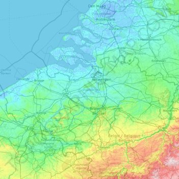
Name: Flanders topographic map, elevation, terrain.
Location: Flanders, Belgium (50.68738 2.54136 51.50511 5.91111)
Average elevation: 61 m
Minimum elevation: -7 m
Maximum elevation: 641 m
Other topographic maps
Click on a map to view its topography, its elevation and its terrain.
Bassin de décantation des résidus miniers
Belgium > Liège > Huy > Wanze > Huccorgne > Le Taillis
Average elevation: 133 m
Tombeau Du Géant
Belgium > Luxembourg > Neufchâteau > Bouillon > Ucimont > Botassart
Average elevation: 300 m
Quatre-Bras de Baisy-Thy
Belgium > Walloon Brabant > Nivelles > Genappe > Baisy-Thy > Quatre-Bras de Baisy-Thy
Average elevation: 146 m
Marche-en-Famenne
Belgium > Luxembourg > Marche-en-Famenne > Marche-en-Famenne
Average elevation: 252 m
Doode Bemde
Belgium > Flemish Brabant > Leuven > Oud-Heverlee > Sint-Joris-Weert
Average elevation: 48 m