Geolocate

Magheroarty Beach topographic map

Interactive map

Click on the map to display elevation.

About this map

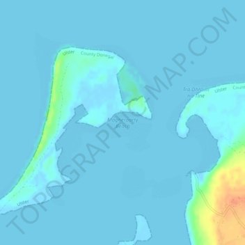
Name: Magheroarty Beach topographic map, elevation, terrain.

Location: Magheroarty Beach, R257, Meenlaragh, Gortahork Electoral Division, Glenties Municipal District, County Donegal, Ireland (55.14508 -8.17294 55.16540 -8.12913)

Average elevation: 3 m

Minimum elevation: -1 m

Maximum elevation: 36 m

Other topographic maps

Click on a map to view its topography, its elevation and its terrain.

Templederry

Ireland > County Tipperary

Average elevation: 274 m

Ballinasloe

Ireland > County Galway

Average elevation: 46 m

Road

Ireland > County Offaly

Average elevation: 87 m

Athlone

Ireland > County Westmeath

Average elevation: 43 m

Kilpatrick

Ireland > County Louth > Ballapousta

Average elevation: 96 m

County Mayo

Ireland

Average elevation: 66 m

Cork

Ireland > County Cork

The climate of Cork, like the majority of Ireland, is mild oceanic (Cfb in the Köppen climate classification) and changeable with abundant rainfall and a lack of temperature extremes. Cork lies in plant Hardiness zone 9b. Met Éireann maintains a climatological weather station at Cork Airport, a few…

Average elevation: 79 m

Ballinteskin

Ireland > County Kilkenny

Average elevation: 234 m

Clonbur

Ireland > County Galway

Average elevation: 47 m

Enfield

Ireland > County Roscommon

Average elevation: 89 m

Cape Clear

Ireland > County Cork

Average elevation: 10 m

Ardee

Ireland > County Louth > Ardee

Average elevation: 43 m

Delgany

Ireland > County Wicklow > Delgany

Average elevation: 87 m

Greystones

Ireland > County Wicklow > Greystones

Average elevation: 49 m

Cartoon

Ireland > County Longford > Cartoon

Average elevation: 47 m

Shankill

Ireland > County Kilkenny

Average elevation: 120 m

Kilkenny

Ireland > County Kilkenny > Kilkenny

Kilkenny is situated in the Nore Valley on both banks of the River Nore, at the centre of County Kilkenny in the province of Leinster in the south-east of Ireland. It is 117 kilometres (73 mi) away the capital Dublin and 48 kilometres (30 mi) north from the nearest city Waterford. Wexford is 80 kilometres (50…

Average elevation: 62 m

Cartoon

Ireland > County Mayo

Average elevation: 11 m

Malahide

Ireland > County Dublin > Malahide

Average elevation: 10 m

Rowlestown

Ireland > County Dublin > Rowlestown

Average elevation: 49 m

Dún Laoghaire-Rathdown

Ireland

Average elevation: 139 m

Rosetown

Ireland > County Kildare

Average elevation: 106 m

Adamstown

Ireland > County Wexford > Adamstown

Average elevation: 84 m

Cappalusk Electoral Division

Ireland > Faha

Average elevation: 96 m

Offaly

Ireland

Average elevation: 99 m

Scurlogue

Ireland

Average elevation: 189 m

Glynn

Ireland > Saint Mullins

Average elevation: 77 m

Achill Island

Ireland

Average elevation: 42 m

Dromalour

Ireland

Average elevation: 100 m

Knockballymartin

Ireland

Average elevation: 156 m

Crosshaven

Ireland > Crosshaven

Average elevation: 27 m

Ballylongford

Ireland > County Kerry > Ballylongford

Average elevation: 22 m

Munster

Ireland

Average elevation: 66 m