
荣成市 topographic map
Interactive map
Click on the map to display elevation.
About this map
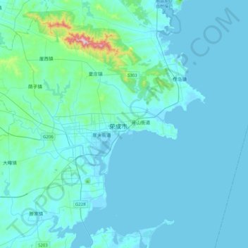
Name: 荣成市 topographic map, elevation, terrain.
Location: 荣成市, 威海市, 山东省, 264300, 中国 (37.00686 122.33197 37.32686 122.65197)
Average elevation: 37 m
Minimum elevation: -2 m
Maximum elevation: 543 m
荣成地处胶东低山丘陵区的东端,海拔虽不甚高,但地形复杂,群山连绵、丘陵起伏、沟壑纵横。有山地、丘陵、平原三种地貌类型,其中山地占全市土地总面积的33.5%, 丘陵占50.4%,平原占16.1%,山脉大都呈东西走向。
Other topographic maps
Click on a map to view its topography, its elevation and its terrain.