
日照市 topographic map
Interactive map
Click on the map to display elevation.
About this map
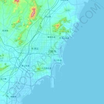
Name: 日照市 topographic map, elevation, terrain.
Location: 日照市, 东港区, 日照市, 山东省, 276800, 中国 (35.25507 119.36145 35.57507 119.68145)
Average elevation: 25 m
Minimum elevation: -4 m
Maximum elevation: 603 m
日照市属鲁东丘陵,总的地势背山面海,中部高四周低,略向东南倾斜,山地、丘陵、平原相间分布。最高点为五莲县境内马耳山,海拔706米;最低点为东港区东海峪村,海拔1~1.5米。山地占总面积的17.5%,丘陵占57.2%,平原占25.3%。
Other topographic maps
Click on a map to view its topography, its elevation and its terrain.