
At Taif topographic map
Interactive map
Click on the map to display elevation.
About this map
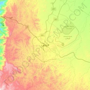
Name: At Taif topographic map, elevation, terrain.
Location: At Taif, Makkah Region, Saudi Arabia (21.11028 40.25583 21.43028 40.57583)
Average elevation: 1,742 m
Minimum elevation: 1,010 m
Maximum elevation: 2,595 m
Ta'if (Arabic: اَلطَّائِفُ; aṭ-Ṭāʾif) is a city in Mecca Province of Saudi Arabia, at an elevation of 1,879 m (6,165 ft) on the slopes of the Sarawat Mountains (Al-Sarawat Mountains). It has a population of 1,200,000 people, is the 5th largest city in Saudi Arabia and the unofficial summer capital. The city is the center of an agricultural area known for its grapes, pomegranate, figs, roses and honey. Taif is well-known as the "City of Roses" and the best summer destination in Saudi Arabia as it enjoys a nice weather during summer.
Other topographic maps
Click on a map to view its topography, its elevation and its terrain.
King Fahad
King Fahad, At Taif, Makkah Region, Saudi Arabia
Average elevation: 1,709 m