
Oblast Magadan topographic map
Interactive map
Click on the map to display elevation.
About this map
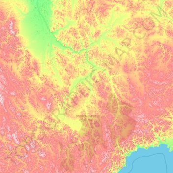
Name: Oblast Magadan topographic map, elevation, terrain.
Location: Oblast Magadan, Föderationskreis Ferner Osten, Russland (60.99150 151.45473 66.11150 156.57473)
Average elevation: 550 m
Minimum elevation: 0 m
Maximum elevation: 2,232 m
Other topographic maps
Click on a map to view its topography, its elevation and its terrain.
Ягоднинский городской округ
Russland > Oblast Magadan > Ягоднинский городской округ
Average elevation: 747 m
Северо-Эвенский городской округ
Russland > Oblast Magadan > Северо-Эвенский городской округ
Average elevation: 469 m
Хасынский городской округ
Russland > Oblast Magadan > Хасынский городской округ
Average elevation: 786 m
Среднеканский городской округ
Russland > Oblast Magadan > Среднеканский городской округ
Average elevation: 502 m
Сусуманский городской округ
Russland > Oblast Magadan > Сусуманский городской округ
Average elevation: 1,038 m
Омсукчанский городской округ
Russland > Oblast Magadan > Омсукчанский городской округ
Average elevation: 542 m
Тенькинский городской округ
Russland > Oblast Magadan > Тенькинский городской округ
Average elevation: 858 m