
Airedale topographic map
Interactive map
Click on the map to display elevation.
About this map
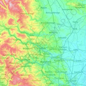
Name: Airedale topographic map, elevation, terrain.
Average elevation: 136 m
Minimum elevation: -1 m
Maximum elevation: 702 m
This valley is of great topographic significance as it provides low-altitude passes through the mid Pennines to the west coast known as the Aire Gap.
Other topographic maps
Click on a map to view its topography, its elevation and its terrain.
Rawcliffe
United Kingdom > England > York
Rawcliffe, York, Yorkshire and the Humber, England, United Kingdom
Average elevation: 14 m
Hogg's Pond
United Kingdom > England > York
Hogg's Pond, Chaloners Road, Woodthorpe, York, Yorkshire and the Humber, England, YO24 2TW, United Kingdom
Average elevation: 14 m
Stock Hill
United Kingdom > England > York
Stock Hill, York, Yorkshire and the Humber, England, YO23 3PW, United Kingdom
Average elevation: 28 m