
The Cape topographic map
Interactive map
Click on the map to display elevation.
About this map
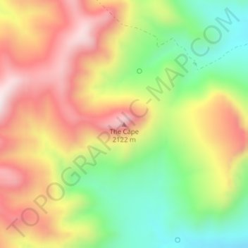
Name: The Cape topographic map, elevation, terrain.
Location: The Cape, Cochise County, Arizona, United States (31.82281 -110.40207 31.82291 -110.40197)
Average elevation: 1,849 m
Minimum elevation: 1,556 m
Maximum elevation: 2,145 m
Other topographic maps
Click on a map to view its topography, its elevation and its terrain.
Flagstaff
United States > Arizona > Coconino County
Flagstaff is the county seat of Coconino County. According to the United States Census Bureau, the city has a total area of 63.9 square miles (165.5 km2), of which only 0.03 square miles (0.08 km2) (0.08%) is water. Flagstaff lies at approximately 7,000 feet (2,130 m) elevation, and is surrounded by the…
Average elevation: 2,176 m