
Arcadia topographic map
Interactive map
Click on the map to display elevation.
Arcadia
Arcadia is located slightly northwest of the center of DeSoto County at 27°13'N 81°52'W (27.2176, –81.8599). The Peace River flows past the west side of the city on its way southwest to tidewater at Punta Gorda. Most of Arcadia is more than 40 feet (12 m) above sea level and portions of Arcadia near the center of the city are as high as 65 feet (20 m) above sea level, giving Arcadia one of the highest elevations for a city in Florida.
About this map
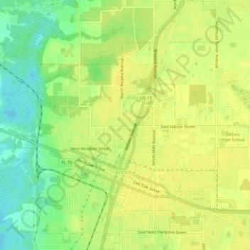
Name: Arcadia topographic map, elevation, terrain.
Location: Arcadia, DeSoto County, Florida, United States (27.20230 -81.87990 27.24557 -81.83451)
Average elevation: 17 m
Minimum elevation: 2 m
Maximum elevation: 24 m
Other topographic maps
Click on a map to view its topography, its elevation and its terrain.
Southfort
United States > Florida > DeSoto County
It is located at 27°04′05″N 81°57′50″W / 27.068°N 81.964°W / 27.068; -81.964, its elevation 26 feet (7.9 m).
Average elevation: 9 m
Hull
United States > Florida > DeSoto County > Hull
Hull is located at 27°07′08″N 81°56′31″W / 27.119°N 81.942°W / 27.119; -81.942, with an elevation of 39 feet (12 m).
Average elevation: 10 m