
Baglung topographic map
Interactive map
Click on the map to display elevation.
About this map
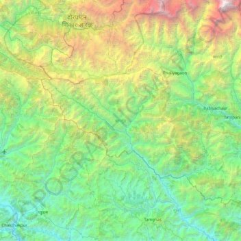
Name: Baglung topographic map, elevation, terrain.
Location: Baglung, Gandaki Pradesh, 33300, Nepal (28.07739 82.87511 28.63544 83.67431)
Average elevation: 2,326 m
Minimum elevation: 528 m
Maximum elevation: 8,142 m
Highest temperature at the lowest elevation of baglung rises up to about 37.5 degrees Celsius in summer and the lowest temperature at Dhorpatan falls up to about −15 degrees Celsius in winter. The elevation of Baglung varies from about 650 meters at Kharbang to about 4,300 meters in Dhorpatan.