
Rogers County topographic map
Interactive map
Click on the map to display elevation.
About this map
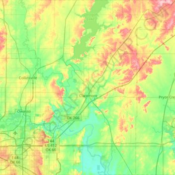
Name: Rogers County topographic map, elevation, terrain.
Location: Rogers County, Oklahoma, United States of America (36.07516 -95.81804 36.59881 -95.32825)
Average elevation: 205 m
Minimum elevation: 161 m
Maximum elevation: 301 m
Other topographic maps
Click on a map to view its topography, its elevation and its terrain.
Wright City
United States of America > Oklahoma > Wright City
Wright City, McCurtain County, Oklahoma, 74766, United States of America
Average elevation: 127 m