
Pangkor Island topographic map
Interactive map
Click on the map to display elevation.
About this map
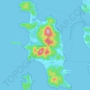
Name: Pangkor Island topographic map, elevation, terrain.
Location: Pangkor Island, Manjung, Perak, 32300, Malaysia (4.18816 100.53573 4.26642 100.58269)
Average elevation: 26 m
Minimum elevation: -2 m
Maximum elevation: 357 m
Other topographic maps
Click on a map to view its topography, its elevation and its terrain.
Pantai Puteri Dewi
Malaysia > Perak > Pangkor Island
Pantai Puteri Dewi, Pangkor Island, Manjung, Perak, 32300, Malaysia
Average elevation: 29 m
Coral Island
Malaysia > Perak > Pangkor Island
Coral Island, A207, Teluk Nipah, Pangkor Island, Perak, 32300, Malaysia
Average elevation: 22 m
Teluk Ketapang Beach
Malaysia > Perak > Pangkor Island
Teluk Ketapang Beach, Jalan Pasir Bogak, Pasir Bogak, Pangkor Island, Perak, 32300, Malaysia
Average elevation: 38 m