
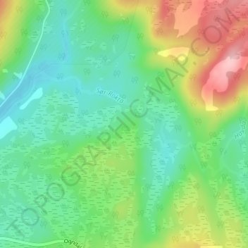
Sør-Rokta topographic map
Interactive map
Click on the map to display elevation.
About this map
Name: Sør-Rokta topographic map, elevation, terrain.
Location: Sør-Rokta, Steinkjer, Trøndelag, 7718, Norway (63.98094 11.95954 63.99119 12.00190)
Average elevation: 214 m
Minimum elevation: 165 m
Maximum elevation: 315 m
Other topographic maps
Click on a map to view its topography, its elevation and its terrain.
Finnmark
The county's interior parts are part of the great Finnmarksvidda plateau, with an elevation of 300 to 400 m (980 to 1,310 ft), with numerous lakes and river valleys. The plateau is famous for its tens of thousands of reindeer owned by the Sámi, and swarms of mosquitoes in midsummer. Finnmarksvidda makes up…
Average elevation: 227 m
Bodø
Snow cover during winter varies, and is often sparse or lacking in the city center, while being more reliable only slightly inland or at some altitude. The largest recorded snow depth at the airport is 90 centimetres (35 in) in February 1976. Located on a peninsula in the Norwegian Sea, Bodø is known to be a…
Average elevation: 114 m