
Thank you for supporting this site ❤️
Make a donation
Make a donation
Quillacollo topographic map
Click on the map to display elevation.
Thank you for supporting this site ❤️
Make a donation
Make a donation
About this map
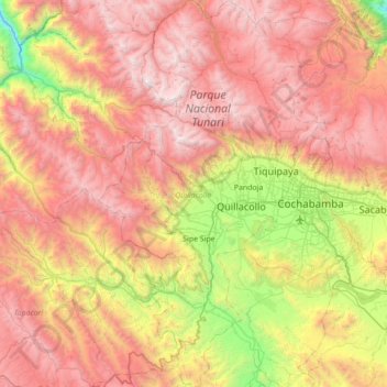
Name: Quillacollo topographic map, elevation, terrain.
Location: Quillacollo, Cochabamba, Bolivia (-17.70734 -66.53891 -17.04500 -66.09400)
Average elevation: 3,463 m
Minimum elevation: 1,824 m
Maximum elevation: 5,046 m
Thank you for supporting this site ❤️
Make a donation
Make a donation
Other topographic maps
Click on a map to view its topography, its elevation and its terrain.
Thank you for supporting this site ❤️
Make a donation
Make a donation
Thank you for supporting this site ❤️
Make a donation
Make a donation
Thank you for supporting this site ❤️
Make a donation
Make a donation
Thank you for supporting this site ❤️
Make a donation
Make a donation
Thank you for supporting this site ❤️
Make a donation
Make a donation