
Pine Mountain Club topographic map
Interactive map
Click on the map to display elevation.
Pine Mountain Club
Pine Mountain Club has an area of 16.7 square miles (43.25 km2). It ranges from 4,901 to 6,400 feet (1,494 to 1,951 m) in elevation.
About this map
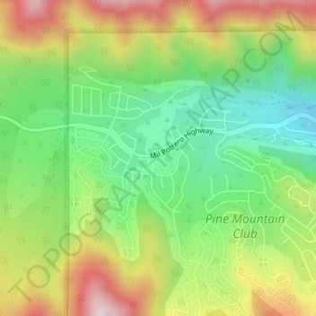
Name: Pine Mountain Club topographic map, elevation, terrain.
Average elevation: 1,754 m
Minimum elevation: 1,535 m
Maximum elevation: 2,054 m
Other topographic maps
Click on a map to view its topography, its elevation and its terrain.
Grass Valley
United States of America > California > Grass Valley
The city of Grass Valley is the largest city in the western region of Nevada County, California, United States. Situated at roughly 2,500 feet (760 m) elevation in the western foothills of the Sierra Nevada mountain range, this historic northern Gold Country city is 57 miles (92 km) by car from the state…
Average elevation: 777 m
Riverside
United States of America > California > Riverside
Riverside is the 59th largest city in the United States, the 12th largest city in California, and the largest city in California's Inland Empire metro area. According to the United States Census Bureau, the city has a total area of 81.4 square miles (210.8 km2), of which 81.1 square miles (210 km2) is land and…
Average elevation: 351 m
San Francisco
United States of America > California
Because of its sharp topography and maritime influences, San Francisco exhibits a multitude of distinct microclimates. The high hills in the geographic center of the city are responsible for a 20% variance in annual rainfall between different parts of the city. They also protect neighborhoods directly to their…
Average elevation: 57 m
Clearlake
United States of America > California > Clearlake
Clearlake is a city in Lake County, California, United States. Clearlake is 4.5 miles (7.2 km) north-northwest of Lower Lake, at an elevation of 1417 feet (432 m). As of the 2010 census, the city had a total population of 15,250, up from 13,142 in 2000. It takes its name from Clear Lake.
Average elevation: 474 m
Salton Sea
United States of America > California > Salton City
The lake occupies the lowest elevations of the Salton Sink in the Colorado Desert of Imperial and Riverside counties in Southern California. Its surface is 236.0 ft (71.9 m) below sea level as of January 2018. The deepest point of the sea is 5 ft (1.5 m) higher than the lowest point of Death Valley. The sea is…
Average elevation: 17 m
Rancho Santa Fe
United States of America > California > Rancho Santa Fe
The climate of Rancho Santa Fe is, for the most part, typical of the San Diego metropolitan area though its higher elevation and inland location lends itself to larger temperature variations.
Average elevation: 68 m
Kelseyville
United States of America > California > Kelseyville
Kelseyville is a census-designated place (CDP) in Lake County, California, United States. Kelseyville is located 6 miles (9.7 km) southeast of Lakeport, at an elevation of 1,384 feet (422 m). The population was 3,353 at the 2010 census, up from 2,928 at the 2000 census.
Average elevation: 462 m
Thousand Oaks
United States of America > California > Thousand Oaks
The northern parts consist of mountainous terrain in the Simi Hills, Conejo Mountains and Mount Clef Ridge. Narrow canyons such as Hill Canyon cut through the steeper mountainous areas. Conejo Mountain and Conejo Grade are found in westernmost Newbury Park, while the southernmost parts of Thousand Oaks are…
Average elevation: 303 m
Montara
United States of America > California
The rare and endangered species Hickman's potentilla occurs at the northern extremity of Montara on the slopes above Martini Creek at elevations ranging from 32 to 410 feet (10 to 125 meters).
Average elevation: 53 m