
Lublin Voivodeship topographic map
Interactive map
Click on the map to display elevation.
About this map
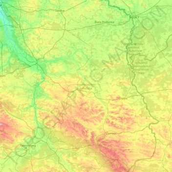
Name: Lublin Voivodeship topographic map, elevation, terrain.
Location: Lublin Voivodeship, Poland (50.25182 21.61555 52.28784 24.14578)
Average elevation: 182 m
Minimum elevation: 80 m
Maximum elevation: 479 m
Other topographic maps
Click on a map to view its topography, its elevation and its terrain.
Zaryte
Poland > Lublin Voivodeship > Ryki County
Zaryte, gmina Kłoczew, Ryki County, Lublin Voivodeship, Poland
Average elevation: 165 m
Bieszczady
Poland > Lublin Voivodeship > Luchów Górny
Bieszczady, Luchów Górny, gmina Tarnogród, powiat biłgorajski, Lublin Voivodeship, 23-420, Poland
Average elevation: 239 m