
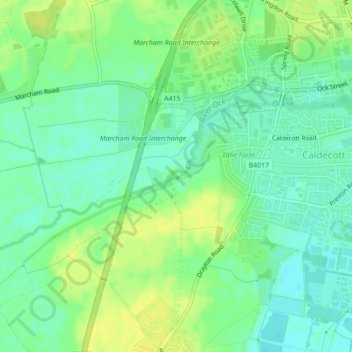
River Ock topographic map
Interactive map
Click on the map to display elevation.
About this map
Name: River Ock topographic map, elevation, terrain.
Average elevation: 56 m
Minimum elevation: 47 m
Maximum elevation: 66 m
Other topographic maps
Click on a map to view its topography, its elevation and its terrain.
Wantage
United Kingdom > England > Vale of White Horse > Wantage
Wantage, Oxfordshire, South East, England, OX12 8DR, United Kingdom
Average elevation: 117 m
Wytham Woods
United Kingdom > England > Vale of White Horse > Wytham
Wytham Woods, Wytham, Vale of White Horse, Oxfordshire, South East England, England, OX2 9BQ, United Kingdom
Average elevation: 84 m
Abingdon on Thames
United Kingdom > England > Vale of White Horse
Abingdon on Thames, Vale of White Horse, Oxfordshire, South East, England, United Kingdom
Average elevation: 61 m
Youlbury Wood
United Kingdom > England > Vale of White Horse > Henwood
Youlbury Wood, Wootton, Henwood, Vale of White Horse, Oxfordshire, South East England, England, United Kingdom
Average elevation: 123 m
Longcot
United Kingdom > England > Vale of White Horse > Longcot
Longcot, Vale of White Horse, Oxfordshire, South East England, England, SN7 7TB, United Kingdom
Average elevation: 93 m
The White Horse
United Kingdom > England > Vale of White Horse
The White Horse, Dragon Hill Road, Woolstone, Vale of White Horse, Oxfordshire, South East, England, SN7 7QH, United Kingdom
Average elevation: 174 m
East Hanney
United Kingdom > England > Vale of White Horse > East Hanney
East Hanney, Vale of White Horse, Oxfordshire, South East, England, OX12 0JQ, United Kingdom
Average elevation: 64 m
Badbury Clump
United Kingdom > England > Vale of White Horse
Badbury Clump, Highworth Road, Great Coxwell, Vale of White Horse, Oxfordshire, South East, England, SN7 7NL, United Kingdom
Average elevation: 110 m
Great Faringdon
United Kingdom > England > Vale of White Horse
Great Faringdon, Vale of White Horse, Oxfordshire, South East, England, United Kingdom
Average elevation: 91 m
Fyfield and Tubney
United Kingdom > England > Vale of White Horse
Fyfield and Tubney, Vale of White Horse, Oxfordshire, South East, England, United Kingdom
Average elevation: 73 m
Eaton
United Kingdom > England > Vale of White Horse > Cumnor > Eaton
Eaton, Appleton-with-Eaton, Cumnor, Vale of White Horse, Oxfordshire, South East, England, OX13 5PR, United Kingdom
Average elevation: 87 m