
Gdyel topographic map
Interactive map
Click on the map to display elevation.
About this map
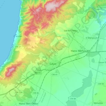
Name: Gdyel topographic map, elevation, terrain.
Location: Gdyel, Daïra Gdyel, Oran, Algérie (35.72288 -0.51052 35.87235 -0.36515)
Average elevation: 173 m
Minimum elevation: 0 m
Maximum elevation: 624 m
Other topographic maps
Click on a map to view its topography, its elevation and its terrain.
Menadsia
Algérie > Oran > Daïra Gdyel > Ben Freha
Menadsia, Ben Freha, Daïra Gdyel, Oran, Algérie
Average elevation: 114 m
Hassiane Etoual
Algérie > Oran > Daïra Gdyel > Ben Freha
Hassiane Etoual, Ben Freha, Daïra Gdyel, Oran, Algérie
Average elevation: 104 m