
Shikoku Region topographic map
Interactive map
Click on the map to display elevation.
About this map
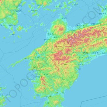
Name: Shikoku Region topographic map, elevation, terrain.
Location: Ehime Prefecture, Shikoku Region, Japan (32.78602 131.88036 34.31825 133.69280)
Average elevation: 172 m
Minimum elevation: -3 m
Maximum elevation: 1,854 m
Other topographic maps
Click on a map to view its topography, its elevation and its terrain.
Mt. Tsurugi
Japan > Shikoku Region > Naka
Mt. Tsurugi, Naka, Naka County, Tokushima Prefecture, Shikoku Region, 779-4306, Japan
Average elevation: 1,584 m