
Stockholm County topographic map
Interactive map
Click on the map to display elevation.
About this map
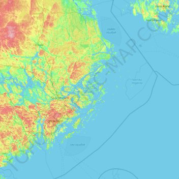
Name: Stockholm County topographic map, elevation, terrain.
Location: Stockholm County, Region Svealand, Sweden (58.48580 17.24357 60.30070 20.01410)
Average elevation: 12 m
Minimum elevation: -6 m
Maximum elevation: 111 m
Other topographic maps
Click on a map to view its topography, its elevation and its terrain.
Sigtuna kommun
Sweden > Stockholm County > Sigtuna kommun
Sigtuna kommun, Sigtuna, Sveriges Landskap, Stockholm County, Region Svealand, 19045, Sweden
Average elevation: 28 m
Rönninge By
Sweden > Stockholm County > Rönninge By
Rönninge By, Täby, Stockholm County, Region Svealand, 18361, Sweden
Average elevation: 17 m
Trångan
Trångan, Norrtälje, Stockholm County, Region Svealand, Sweden
Average elevation: 0 m