
Inyo County topographic map
Interactive map
Click on the map to display elevation.
About this map
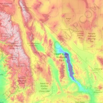
Name: Inyo County topographic map, elevation, terrain.
Location: Inyo County, California, United States of America (35.78658 -118.79005 37.46493 -115.64806)
Average elevation: 1,473 m
Minimum elevation: -83 m
Maximum elevation: 4,242 m
Mount Whitney, the highest peak in the contiguous United States, is on Inyo County's western border (with Tulare County). The Badwater Basin in Death Valley National Park, the lowest place in North America, is in eastern Inyo County. The difference between the two points is about 14,700 feet (4,500 m). They are not visible from each other, but both can be observed from the Panamint Range on the west side of Death Valley, above the Panamint Valley. Thus, Inyo County has the greatest elevation difference among all of the counties and county-equivalents in the contiguous United States.
Other topographic maps
Click on a map to view its topography, its elevation and its terrain.
San Francisco
United States of America > California
San Francisco, California, United States of America
Average elevation: 57 m
Mono Craters
United States of America > California > June Lake Junction
Mono Craters, Pumice Mine Road, June Lake Junction, Mono County, California, 93529, United States of America
Average elevation: 2,541 m
Palo Alto
United States of America > California > Palo Alto
Palo Alto, Santa Clara County, California, United States of America
Average elevation: 188 m
El Dorado County
United States of America > California
El Dorado County, California, United States of America
Average elevation: 1,286 m
Alpine County
United States of America > California
Alpine County, California, United States of America
Average elevation: 2,216 m
Riverside County
United States of America > California
Riverside County, California, United States of America
Average elevation: 538 m
Los Angeles County
United States of America > California
Los Angeles County, California, United States of America
Average elevation: 382 m