
Alps topographic map
Interactive map
Click on the map to display elevation.
Alps
The altitude and size of the range affect the climate in Europe; in the mountains, precipitation levels vary greatly and climatic conditions consist of distinct zones. Wildlife such as ibex live in the higher peaks to elevations of 3,400 m (11,155 ft), and plants such as Edelweiss grow in rocky areas in lower elevations as well as in higher elevations.
About this map
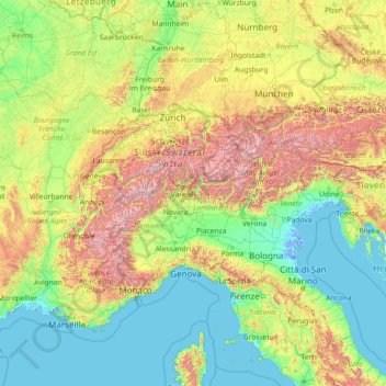
Name: Alps topographic map, elevation, terrain.
Location: Alps, Italy (43.40773 5.04557 48.40929 16.60584)
Average elevation: 526 m
Minimum elevation: -6 m
Maximum elevation: 4,155 m
Other topographic maps
Click on a map to view its topography, its elevation and its terrain.
Nanno
Italy > Trentino-Alto Adige/Südtirol > Provincia di Trento > Ville d'Anaunia
Average elevation: 534 m
Costasavina
Italy > Trentino – Alto Adige/Südtirol > Provincia di Trento > Pergine Valsugana > Susà
Average elevation: 626 m