
Ojai topographic map
Interactive map
Click on the map to display elevation.
About this map
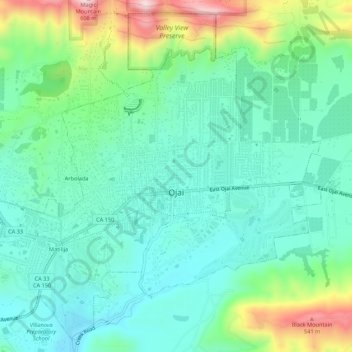
Name: Ojai topographic map, elevation, terrain.
Location: Ojai, Ventura County, California, 93023, United States (34.42924 -119.27457 34.47065 -119.22062)
Average elevation: 289 m
Minimum elevation: 180 m
Maximum elevation: 592 m
Nordhoff Ridge, the western extension of the Topatopa Mountains, towers over the north side of the valley at more than 5,000 feet (1,500 m). Sulphur Mountain creates the southern ranges bounding the Ojai Valley, a little under 3,000 feet (910 m) in elevation. The Sulphur and Topatopa mountains are part of the Transverse Ranges system. The Ojai Valley and the surrounding mountains are heavily wooded with oak trees.
Other topographic maps
Click on a map to view its topography, its elevation and its terrain.
Oak View
United States > California > Ventura County
Oak View, Ventura County, CAL Fire Southern Region, California, 93022, United States
Average elevation: 184 m
Jasmine Glen Estates
United States > California > Ventura County > Simi Valley
Jasmine Glen Estates, Simi Valley, Ventura County, CAL Fire Southern Region, California, 90363, United States
Average elevation: 331 m
San Buenaventura (Ventura)
United States > California > Ventura County
San Buenaventura (Ventura), Ventura County, CAL Fire Southern Region, California, United States
Average elevation: 158 m
SSFL South Buffer
United States > California > Ventura County
SSFL South Buffer, Ventura County, CAL Fire Contract Counties, California, United States
Average elevation: 504 m
Port Hueneme
United States > California > Ventura County
Port Hueneme, Ventura County, CAL Fire Southern Region, California, United States
Average elevation: 7 m
Lake Sherwood
United States > California > Ventura County
Lake Sherwood, Ventura County, California, United States
Average elevation: 332 m
Newbury Park
United States > California > Ventura County > Thousand Oaks > Newbury Park
Newbury Park, Thousand Oaks, Ventura County, California, 91320, United States
Average elevation: 262 m
Somis
United States > California > Ventura County
Somis, Ventura County, CAL Fire Southern Region, California, 93066, United States
Average elevation: 112 m
Simi Valley
United States > California > Ventura County > Simi Valley
Simi Valley, Ventura County, California, 93063-2364, United States
Average elevation: 379 m
Simi Valley
United States > California > Ventura County
Simi Valley, Ventura County, California, United States
Average elevation: 405 m
Thousand Oaks
United States > California > Ventura County
Thousand Oaks, Ventura County, California, United States
Average elevation: 333 m
Strathearn
United States > California > Ventura County > Simi Valley
Strathearn, Simi Valley, Ventura County, CAL Fire Southern Region, California, 93065, United States
Average elevation: 261 m
Santa Paula
United States > California > Ventura County
Santa Paula, Ventura County, CAL Fire Southern Region, California, United States
Average elevation: 148 m
Greenwich Village
United States > California > Ventura County > Thousand Oaks > Greenwich Village
Greenwich Village, Thousand Oaks, Ventura County, California, 91360-4401, United States
Average elevation: 275 m
Casitas Springs
United States > California > Ventura County > Ventura > Casitas Springs
Casitas Springs, Ventura, Ventura County, California, 93022, United States
Average elevation: 182 m
Johnson Creek Park
United States > California > Ventura County > Oxnard > Pleasant Valley Mobile Home Park
Johnson Creek Park, Pleasant Valley Mobile Home Park, Oxnard, Ventura County, California, United States
Average elevation: 10 m
Oxnard
United States > California > Ventura County
Oxnard, Ventura County, California, United States
Average elevation: 16 m
Anacapa Island
United States > California > Ventura County
Anacapa Island, Ventura County, California, United States
Average elevation: 4 m
Thousand Oaks
United States > California > Ventura County > Thousand Oaks
Thousand Oaks, Ventura County, California, United States
Average elevation: 303 m
Ventura
United States > California > Ventura County
Ventura, Ventura County, CAL Fire Southern Region, California, United States
Average elevation: 120 m
Camarillo
United States > California > Ventura County
Camarillo, Ventura County, CAL Fire Southern Region, California, United States
Average elevation: 90 m