
Marne topographic map
Interactive map
Click on the map to display elevation.
About this map
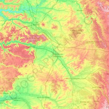
Name: Marne topographic map, elevation, terrain.
Location: Marne, Grand Est, Metropolitan France, France (48.51527 3.39589 49.40742 5.04010)
Average elevation: 148 m
Minimum elevation: 43 m
Maximum elevation: 341 m
Other topographic maps
Click on a map to view its topography, its elevation and its terrain.
Waltenheim-sur-Zorn
Waltenheim-sur-Zorn, Saverne, Bas-Rhin, Grand Est, Metropolitan France, 67670, France
Average elevation: 178 m
Le Clerjus
Le Clerjus, Épinal, Vosges, Grand Est, Metropolitan France, 88240, France
Average elevation: 443 m
Vic-sur-Seille
Vic-sur-Seille, Sarrebourg-Château-Salins, Moselle, Grand Est, Metropolitan France, 57630, France
Average elevation: 240 m
La Chaussée de Damery
La Chaussée de Damery, Vauciennes, Épernay, Marne, Grand Est, Metropolitan France, 51480, France
Average elevation: 136 m
Saint-Martin
France > Grand Est > Saint-Martin
Saint-Martin, Lunéville, Meurthe-et-Moselle, Grand Est, Metropolitan France, 54450, France
Average elevation: 262 m
Thin-le-Moutier
France > Grand Est > Thin-le-Moutier
Thin-le-Moutier, Charleville-Mézières, Ardennes, Grand Est, Metropolitan France, 08460, France
Average elevation: 239 m
Bréhain-la-Ville
France > Grand Est > Bréhain-la-Ville
Bréhain-la-Ville, Briey, Meurthe-et-Moselle, Grand Est, Metropolitan France, 54190, France
Average elevation: 407 m
Heillecourt
France > Grand Est > Heillecourt
Heillecourt, Nancy, Meurthe-et-Moselle, Grand Est, Metropolitan France, 54180, France
Average elevation: 236 m
Dornhecke
France > Grand Est > Bischwiller
Dornhecke, Bischwiller, Haguenau-Wissembourg, Bas-Rhin, Grand Est, Metropolitan France, 67240, France
Average elevation: 133 m
Les crouées
France > Grand Est > Dommary-Baroncourt
Les crouées, Dommary-Baroncourt, Verdun, Meuse, Grand Est, Metropolitan France, 55240, France
Average elevation: 245 m
Charleville-Mézières
France > Grand Est > Charleville-Mézières
Charleville-Mézières, Ardennes, Grand Est, Metropolitan France, 08000, France
Average elevation: 201 m
Muhlbach-sur-Munster
France > Grand Est > Muhlbach-sur-Munster
Muhlbach-sur-Munster, Colmar-Ribeauvillé, Haut-Rhin, Grand Est, Metropolitan France, 68380, France
Average elevation: 642 m
Niederbronn-les-Bains
France > Grand Est > Niederbronn-les-Bains
Niederbronn-les-Bains, Haguenau-Wissembourg, Bas-Rhin, Grand Est, Metropolitan France, 67110, France
Average elevation: 293 m
Mainvillers
France > Grand Est > Mainvillers
Mainvillers, Forbach-Boulay-Moselle, Moselle, Grand Est, Metropolitan France, 57380, France
Average elevation: 270 m
Rue du Château
France > Grand Est > Étrelles-sur-Aube
Rue du Château, Étrelles-sur-Aube, Nogent-sur-Seine, Aube, Grand Est, Metropolitan France, 10170, France
Average elevation: 78 m
Sainte-Marie-du-Lac-Nuisement
France > Grand Est > Sainte-Marie-du-Lac-Nuisement
Sainte-Marie-du-Lac-Nuisement, Vitry-le-François, Marne, Grand Est, Metropolitan France, 51290, France
Average elevation: 133 m
Gros Ventre
France > Grand Est > Montépreux
Gros Ventre, Montépreux, Châlons-en-Champagne, Marne, Grand Est, Metropolitan France, 51320, France
Average elevation: 166 m
Vosges
France > Grand Est > Goldbach-Altenbach
Vosges, Goldbach-Altenbach, Thann-Guebwiller, Haut-Rhin, Grand Est, Metropolitan France, 68760, France
Average elevation: 864 m