Geolocate

Eure topographic map

Interactive map

Click on the map to display elevation.

About this map

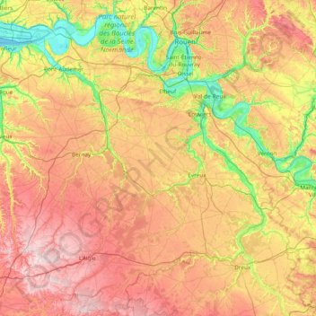
Name: Eure topographic map, elevation, terrain.

Location: Eure, Normandy, Metropolitan France, France (48.66642 0.29616 49.48482 1.80286)

Average elevation: 141 m

Minimum elevation: -3 m

Maximum elevation: 331 m

The department is a largely wooded plateau intersected by the valleys of the river Seine and its tributaries. The altitude varies from sea level in the north to 248 metres above it in the south.

Wikipedia (CC-BY-SA 3.0)

Other topographic maps

Click on a map to view its topography, its elevation and its terrain.

Port-en-Bessin-Huppain

France > Normandy > Calvados

Port-en-Bessin-Huppain, Bayeux, Calvados, Normandy, Metropolitan France, 14520, France

Average elevation: 28 m

Douains

France > Normandy > Eure

Douains, Les Andelys, Eure, Normandy, Metropolitan France, 27120, France

Average elevation: 133 m

Gerponville

France > Normandy > Seine-Maritime

Gerponville, Le Havre, Seine-Maritime, Normandy, Metropolitan France, 76540, France

Average elevation: 112 m

Criel-sur-Mer

France > Normandy > Criel-sur-Mer

Criel-sur-Mer, Dieppe, Seine-Maritime, Normandy, Metropolitan France, 76910, France

Average elevation: 43 m

L'Ay

France > Normandy

L'Ay, Coutances, Manche, Normandy, Metropolitan France, 50200, France

Average elevation: 42 m

Rouen

France > Normandy > Rouen

Rouen, Seine-Maritime, Normandy, Metropolitan France, France

Average elevation: 72 m

Pirou

France > Normandy > Pirou

Pirou, Coutances, Manche, Normandy, Metropolitan France, 50770, France

Average elevation: 13 m

Orival

France > Normandy > Orival

Orival, Rouen, Seine-Maritime, Normandy, Metropolitan France, 76500, France

Average elevation: 69 m

Évreux

France > Normandy > Évreux

Évreux, Eure, Normandy, Metropolitan France, 27000, France

Average elevation: 119 m

Flamanville

France > Normandy > Flamanville

Flamanville, Cherbourg, Manche, Normandy, Metropolitan France, 50340, France

Average elevation: 34 m

Cherbourg-en-Cotentin

France > Normandy > Cherbourg-en-Cotentin

Cherbourg-en-Cotentin, Cherbourg, Manche, Normandy, Metropolitan France, France

Average elevation: 68 m

Le Château Blanc

France > Normandy > Le Château Blanc

Le Château Blanc, Coutances, Manche, Normandy, Metropolitan France, 50770, France

Average elevation: 29 m

Quartier Pasteur

France > Normandy > Rouen

Quartier Pasteur, Rouen, Seine-Maritime, Normandy, Metropolitan France, 76006, France

Average elevation: 31 m

Le Moulin

France > Normandy > Cossesseville

Le Moulin, Cossesseville, Caen, Calvados, Normandy, Metropolitan France, 14690, France

Average elevation: 102 m

Caen

France > Normandy > Caen

Caen, Calvados, Normandy, Metropolitan France, 14000, France

Average elevation: 37 m

La Caine

France > Normandy > La Caine

La Caine, Caen, Calvados, Normandy, Metropolitan France, 14210, France

Average elevation: 159 m