
Ernakulam topographic map
Interactive map
Click on the map to display elevation.
About this map
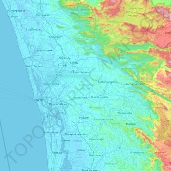
Name: Ernakulam topographic map, elevation, terrain.
Location: Ernakulam, Kerala, India (9.79242 76.16284 10.29418 77.08893)
Average elevation: 196 m
Minimum elevation: -5 m
Maximum elevation: 1,676 m
Other topographic maps
Click on a map to view its topography, its elevation and its terrain.
Kodanad
India > Kerala > Kunnathunad
Kodanad, Kunnathunad, Ernakulam District, Kerala, 683544, India
Average elevation: 19 m
Perinthalmanna
Perinthalmanna, Malappuram District, Kerala, India
Average elevation: 76 m
Nedumkunnam
India > Kerala > Changanassery
Nedumkunnam, Changanassery, Kottayam District, Kerala, 686542, India
Average elevation: 67 m
Meesapulimala
Meesapulimala, Idukki, Kerala, 685618, India
Average elevation: 2,221 m