
Punjab topographic map
Interactive map
Click on the map to display elevation.
About this map
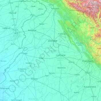
Name: Punjab topographic map, elevation, terrain.
Location: Punjab, India (29.54294 73.87983 32.51118 76.93906)
Average elevation: 477 m
Minimum elevation: 170 m
Maximum elevation: 6,027 m
Punjab is in northwestern India and has a total area of 50,362 square kilometres (19,445 sq mi). Punjab is bounded by Pakistan on the west, Jammu and Kashmir on the north, Himachal Pradesh on the northeast and Haryana and Rajasthan on the south. Most of the Punjab lies in a fertile, alluvial plain with many rivers and an extensive irrigation canal system. A belt of undulating hills extends along the northeastern part of the state at the foot of the Himalayas. Its average elevation is 300 metres (980 ft) above sea level, with a range from 180 metres (590 ft) in the southwest to more than 500 metres (1,600 ft) around the northeast border. The southwest of the state is semiarid, eventually merging into the Thar Desert. The Shiwalik Hills extend along the northeastern part of the state at the foot of the Himalayas.
Other topographic maps
Click on a map to view its topography, its elevation and its terrain.