
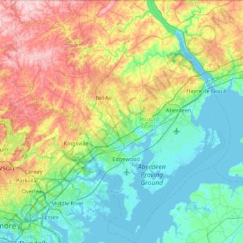
Harford County topographic map
Interactive map
Click on the map to display elevation.
About this map
Name: Harford County topographic map, elevation, terrain.
Location: Harford County, Maryland, United States (39.25801 -76.56945 39.72121 -76.03564)
Average elevation: 70 m
Minimum elevation: -3 m
Maximum elevation: 237 m
Harford County straddles the border between the rolling hills of the Piedmont Plateau and the flatlands of the Atlantic Coastal Plain along the Chesapeake Bay and its tributaries. The county's development is a mix of rural and suburban, with denser development in the larger towns of Aberdeen and Bel Air and along Route 40 and other major arteries leading out of Baltimore. The highest elevations are in the north and northwest of the county, reaching 805 ft. near the Pennsylvania border in the county's northwestern corner. The lowest elevation is sea level along the Chesapeake Bay.
Other topographic maps
Click on a map to view its topography, its elevation and its terrain.
Garrett County
Garrett County, Maryland, United States
Average elevation: 700 m
Chesapeake Bay
Chesapeake Bay, Maryland, 23459, United States
Average elevation: 33 m
College Park
United States > Maryland > Prince George's County
College Park, Prince George's County, Maryland, United States
Average elevation: 38 m
Carroll County
Carroll County, Maryland, United States
Average elevation: 190 m
Anne Arundel County
Anne Arundel County, Maryland, United States
Average elevation: 25 m
Antietam
United States > Maryland > Washington County
Antietam, Washington County, Maryland, 21782, United States
Average elevation: 123 m
Washington County
Washington County, Maryland, United States
Average elevation: 195 m
Montgomery County
Montgomery County, Maryland, United States
Average elevation: 120 m
Bear Branch
United States > Maryland > Carroll County > Brown Heights
Bear Branch, Brown Heights, Carroll County, Maryland, United States
Average elevation: 145 m
Bethesda
United States > Maryland > Bethesda
Bethesda, Montgomery County, Maryland, 22814, United States
Average elevation: 86 m
Hagerstown
United States > Maryland > Washington County
Hagerstown, Washington County, Maryland, United States
Average elevation: 170 m
Fountain Green
United States > Maryland > Harford County > Bel Air
Fountain Green, Bel Air, Harford County, Maryland, 21015, United States
Average elevation: 106 m
Kent Island
United States > Maryland > Queen Anne's County > Chester
Kent Island, Chester, Queen Anne's County, Maryland, United States
Average elevation: 1 m
Silver Spring
United States > Maryland > Montgomery County > Silver Spring
Silver Spring, Montgomery County, Maryland, United States
Average elevation: 86 m
Annapolis
United States > Maryland > Anne Arundel County
Annapolis, Anne Arundel County, Maryland, United States
Average elevation: 8 m
Flat Run
United States > Maryland > Frederick County > Emmitsburg
Flat Run, Emmitsburg, Frederick County, Maryland, United States
Average elevation: 138 m
Mount Airy
United States > Maryland > Carroll County
Mount Airy, Carroll County, Maryland, 21771, United States
Average elevation: 221 m
Gaithersburg
United States > Maryland > Montgomery County
Gaithersburg, Montgomery County, Maryland, United States
Average elevation: 137 m
Ocean City
United States > Maryland > Ocean City
Ocean City, Worcester County, Maryland, 21843, United States
Average elevation: 1 m
Hereford
United States > Maryland > Baltimore County
Hereford, Baltimore County, Maryland, United States
Average elevation: 170 m
Keedysville
United States > Maryland > Washington County
Keedysville, Washington County, Maryland, United States
Average elevation: 129 m
Belle Grove Square
United States > Maryland > Carroll County > Westminster
Belle Grove Square, Westminster, Carroll County, Maryland, 21157, United States
Average elevation: 224 m
Owings
United States > Maryland > Calvert County
Owings, Calvert County, Maryland, 20736, United States
Average elevation: 35 m
Laytonsville
United States > Maryland > Montgomery County
Laytonsville, Montgomery County, Maryland, United States
Average elevation: 172 m
Madonna
United States > Maryland > Harford County
Madonna, Harford County, Maryland, 21084, United States
Average elevation: 199 m
Yorktown
United States > Maryland > Anne Arundel County > Glen Burnie
Yorktown, Glen Burnie, Anne Arundel County, Maryland, 21108, United States
Average elevation: 30 m
Auth Village
United States > Maryland > Prince George's County > Camp Springs
Auth Village, Camp Springs, Prince George's County, Maryland, 20746, United States
Average elevation: 77 m
Port Heights
United States > Maryland > Cecil County
Port Heights, Cecil County, Maryland, 21094, United States
Average elevation: 69 m
Catonsville
United States > Maryland > Baltimore County
Catonsville, Baltimore County, Maryland, 21228, United States
Average elevation: 104 m
Pasadena
United States > Maryland > Anne Arundel County
Pasadena, Anne Arundel County, Maryland, 21122, United States
Average elevation: 16 m
Frostburg
United States > Maryland > Allegany County
Frostburg, Allegany County, Maryland, 21532, United States
Average elevation: 620 m
Deer Park
United States > Maryland > Garrett County
Deer Park, Garrett County, Maryland, United States
Average elevation: 774 m
Swanton
United States > Maryland > Garrett County
Swanton, Garrett County, Maryland, 21561, United States
Average elevation: 789 m
Shallmar
United States > Maryland > Garrett County
Shallmar, Garrett County, Maryland, 21538, United States
Average elevation: 653 m
Loch Lynn Heights
United States > Maryland > Garrett County
Loch Lynn Heights, Garrett County, Maryland, United States
Average elevation: 747 m
Saint Inigoes Shores
United States > Maryland > Saint Mary's County
Saint Inigoes Shores, Saint Mary's County, Maryland, 20684, United States
Average elevation: 5 m
Ocean Pines
United States > Maryland > Worcester County
Ocean Pines, Worcester County, Maryland, 21811, United States
Average elevation: 3 m
Damascus
United States > Maryland > Montgomery County
Damascus, Montgomery County, Maryland, 20872, United States
Average elevation: 204 m
Clarksburg
United States > Maryland > Montgomery County
Clarksburg, Montgomery County, Maryland, United States
Average elevation: 166 m
White Oak
United States > Maryland > Montgomery County
White Oak, Montgomery County, Maryland, 20904, United States
Average elevation: 96 m
Perry Hall
United States > Maryland > Baltimore County
Perry Hall, Baltimore County, Maryland, 21236, United States
Average elevation: 72 m
Montgomery Village
United States > Maryland > Montgomery County
Montgomery Village, Montgomery County, Maryland, 20886, United States
Average elevation: 139 m
Glenelg
United States > Maryland > Howard County
Glenelg, Howard County, Maryland, 21737, United States
Average elevation: 171 m
Mount Rainier
United States > Maryland > Prince George's County
Mount Rainier, Prince George's County, Maryland, 20712, United States
Average elevation: 20 m
Dundalk
United States > Maryland > Baltimore County
Dundalk, Baltimore County, Maryland, 21222, United States
Average elevation: 33 m
Catoctin Creek
United States > Maryland > Frederick County > Middletown
Catoctin Creek, Middletown, Frederick County, Maryland, United States
Average elevation: 188 m
Doubs
United States > Maryland > Frederick County > Adamstown
Doubs, Adamstown, Frederick County, Maryland, 21790, United States
Average elevation: 97 m
Kemp Mill
United States > Maryland > Montgomery County
Kemp Mill, Montgomery County, Maryland, 20901, United States
Average elevation: 104 m