
Kasteel Neubourg topographic map
Interactive map
Click on the map to display elevation.
About this map
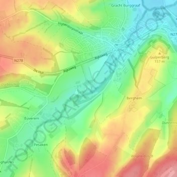
Name: Kasteel Neubourg topographic map, elevation, terrain.
Average elevation: 137 m
Minimum elevation: 88 m
Maximum elevation: 196 m
Other topographic maps
Click on a map to view its topography, its elevation and its terrain.
Elkenrade
Nederland > Limburg > Gulpen-Wittem
Elkenrade, Gulpen-Wittem, Limburg, Nederland
Average elevation: 150 m
Kasteel Wittem
Nederland > Limburg > Gulpen-Wittem
Kasteel Wittem, Voetpad Te Wittem, Wittem, Gulpen-Wittem, Limburg, Nederland, 6286AA, Nederland
Average elevation: 116 m