
Rabun County topographic map
Interactive map
Click on the map to display elevation.
About this map
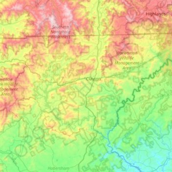
Name: Rabun County topographic map, elevation, terrain.
Location: Rabun County, Georgia, United States (34.71594 -83.66164 35.00068 -83.09834)
Average elevation: 687 m
Minimum elevation: 198 m
Maximum elevation: 1,650 m
The Eastern Continental Divide runs through the county, roughly from southwest to northeast, also representing a portion of the Tennessee Valley Divide. The county's eastern border with South Carolina is formed by the Chattooga River, the largest tributary of the Tugaloo River and then Savannah River (which forms the rest of the border of the two states). The north-central portion of Rabun County is in the watershed of the Little Tennessee River, which flows northward from Mountain City. The high elevation along the divide gives Rabun County the most snow of any in county in Georgia. This also gives it mild weather throughout the warmer months of the year, leading to the county's slogan, Where Spring Spends the Summer. Rabun County is the only county in Georgia with three state parks: Black Rock Mountain, Moccasin Creek, and Tallulah Gorge.
Other topographic maps
Click on a map to view its topography, its elevation and its terrain.
Atlanta
United States > Georgia > Fulton County
Atlanta, Fulton County, Georgia, United States
Average elevation: 284 m
Savannah
United States > Georgia > Chatham County
Savannah, Chatham County, Georgia, United States
Average elevation: 4 m
Athens
United States > Georgia > Athens
Athens, Athens-Clarke County, Georgia, 303341458, United States
Average elevation: 221 m
Blue Ridge
United States > Georgia > Fannin County
Blue Ridge, Fannin County, Georgia, United States
Average elevation: 535 m
Augusta
United States > Georgia > Augusta
Augusta, Richmond County, Georgia, 30901, United States
Average elevation: 90 m
Dahlonega
United States > Georgia > Lumpkin County
Dahlonega, Lumpkin County, Georgia, United States
Average elevation: 411 m
Georgia International Horse Park
United States > Georgia > Rockdale County > Conyers
Georgia International Horse Park, Conyers, Rockdale County, Georgia, United States
Average elevation: 209 m
Gwinnett County
Gwinnett County, Georgia, United States
Average elevation: 302 m
Columbus
United States > Georgia > Muscogee County
Columbus, Muscogee County, Georgia, United States
Average elevation: 130 m
Helen
United States > Georgia > White County
Helen, White County, Georgia, 30545, United States
Average elevation: 488 m
Ellijay
United States > Georgia > Gilmer County
Ellijay, Gilmer County, Georgia, 30540, United States
Average elevation: 424 m
Tybee Island
United States > Georgia > Chatham County
Tybee Island, Chatham County, Georgia, 31328, United States
Average elevation: 1 m
Saint Simons Island
United States > Georgia > Glynn County
Saint Simons Island, Glynn County, Georgia, 31561, United States
Average elevation: 2 m
Macon
United States > Georgia > Bibb County
Macon, Bibb County, Georgia, United States
Average elevation: 127 m
Atlanta
United States > Georgia > Fulton County
Atlanta, Fulton County, Georgia, 30303, United States
Average elevation: 285 m
Alpharetta
United States > Georgia > Fulton County
Alpharetta, Fulton County, Georgia, United States
Average elevation: 324 m
Blairsville
United States > Georgia > Union County
Blairsville, Union County, Georgia, United States
Average elevation: 587 m
Vinings
United States > Georgia > Cobb County
Vinings, Cobb County, Georgia, 30339, United States
Average elevation: 281 m
Hiawassee
United States > Georgia > Towns County
Hiawassee, Towns County, Georgia, United States
Average elevation: 620 m
Skidaway Island
United States > Georgia > Chatham County
Skidaway Island, Chatham County, Georgia, 31411, United States
Average elevation: 3 m
Brunswick
United States > Georgia > Glynn County
Brunswick, Glynn County, Georgia, United States
Average elevation: 2 m
Lumpkin
United States > Georgia > Stewart County
Lumpkin, Stewart County, Georgia, United States
Average elevation: 147 m
Gainesville
United States > Georgia > Hall County
Gainesville, Hall County, Georgia, 30501, United States
Average elevation: 346 m
Canton
United States > Georgia > Cherokee County
Canton, Cherokee County, Georgia, United States
Average elevation: 320 m
Jointer Island
United States > Georgia > Glynn County > Brunswick
Jointer Island, Brunswick, Glynn County, Georgia, United States
Average elevation: 0 m
Heritage Acres
United States > Georgia > Bibb County > Macon
Heritage Acres, Macon, Bibb County, Georgia, 31211, United States
Average elevation: 119 m
Robins Air Force Base
United States > Georgia > Houston County
Robins Air Force Base, Houston County, Georgia, 31098, United States
Average elevation: 92 m
Stone Mountain
United States > Georgia > DeKalb County
Stone Mountain, DeKalb County, Georgia, 30087, United States
Average elevation: 299 m
Woodstock
United States > Georgia > Cherokee County
Woodstock, Cherokee County, Georgia, United States
Average elevation: 296 m
Lake Oconee
United States > Georgia > Greene County > Lake Oconee
Lake Oconee, Greene County, Georgia, United States
Average elevation: 165 m
Mountain City
United States > Georgia > Rabun County
Mountain City, Rabun County, Georgia, 30562, United States
Average elevation: 747 m
Kennesaw
United States > Georgia > Cobb County
Kennesaw, Cobb County, Georgia, 30144, United States
Average elevation: 317 m
Iron Mountain
United States > Georgia > Murray County
Iron Mountain, Murray County, Georgia, United States
Average elevation: 362 m
Fort Pulaski
United States > Georgia > Chatham County
Fort Pulaski, Fort Perimeter Trail, Chatham County, Georgia, 31328, United States
Average elevation: 1 m
Tugaloo
United States > Georgia > Habersham County > Tallulah Falls
Tugaloo, Tallulah Falls, Habersham County, Georgia, United States
Average elevation: 392 m
Elmodel
United States > Georgia > Baker County
Elmodel, Baker County, Georgia, United States
Average elevation: 51 m
Leary
United States > Georgia > Calhoun County
Leary, Calhoun County, Georgia, 39862, United States
Average elevation: 61 m
Fargo
United States > Georgia > Clinch County
Fargo, Clinch County, Georgia, United States
Average elevation: 34 m
Worley Crossroads
United States > Georgia > Cherokee County
Worley Crossroads, Cherokee County, Georgia, United States
Average elevation: 378 m
Fernwood
United States > Georgia > Fayette County > Peachtree City
Fernwood, Peachtree City, Fayette County, Georgia, 30269, United States
Average elevation: 261 m
Valdosta
United States > Georgia > Lowndes County
Valdosta, Lowndes County, Georgia, United States
Average elevation: 58 m