Geolocate

Mount Ainslie topographic map

Interactive map

Click on the map to display elevation.

Mount Ainslie

Mount Ainslie is a hill with an elevation of 843 metres (2,766 ft) AHD  that is located in the northeastern suburbs of Canberra, in the Australian Capital Territory, Australia. Mount Ainslie lies within part of the Canberra Nature Park.

Wikipedia (CC-BY-SA 3.0)

About this map

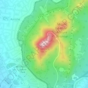
Name: Mount Ainslie topographic map, elevation, terrain.

Location: Mount Ainslie, Canberra, Australian Capital Territory, 2612, Australia (-35.26984 149.15863 -35.26974 149.15873)

Average elevation: 649 m

Minimum elevation: 572 m

Maximum elevation: 839 m

Other topographic maps

Click on a map to view its topography, its elevation and its terrain.

Sydney

Australia > New South Wales

Sydney's topography is characterized by a diverse landscape that seamlessly blends coastal features with inland plateaus. The city is divided into two primary regions: the relatively flat Cumberland Plain to the south and west of Sydney Harbour, and the elevated Hornsby Plateau to the north. The Cumberland…

Average elevation: 53 m

City of Melbourne

Australia > Victoria

Melbourne's topography is characterized by a diverse landscape that transitions from flat coastal plains to rolling hills and mountainous regions. The city is situated at the northern end of Port Phillip Bay, where the terrain is predominantly flat, facilitating urban development. As one moves eastward, the…

Average elevation: 18 m

Victoria

Australia

Victoria contains many topographically, geologically and climatically diverse areas, ranging from the wet, temperate climate of Gippsland in the southeast to the snow-covered Victorian alpine areas which rise to almost 2,000 m (6,600 ft), with Mount Bogong the highest peak at 1,986 m (6,516 ft). There are…

Average elevation: 179 m

South Australia

Australia

Average elevation: 110 m

Tasmania

Australia > Tasmania

The most mountainous region is the Central Highlands area, which covers most of the central western parts of the state. The Midlands located in the central east, is fairly flat, and is predominantly used for agriculture, although farming activity is scattered throughout the state. Tasmania's tallest mountain…

Average elevation: 220 m

New South Wales

Australia

New South Wales (NSW), located on Australia's eastern seaboard, boasts a diverse topography that significantly influences its landscapes and ecosystems. The state's eastern edge is dominated by a narrow coastal plain, featuring regions such as the Illawarra and Shoalhaven near Nowra, characterized by rolling…

Average elevation: 154 m

Western Australia

Australia

Because the only mountain-building since then has been of the Stirling Range with the rifting from Antarctica, the land is extremely eroded and ancient, with no part of the state above 1,245 metres (4,085 ft) AHD (at Mount Meharry in the Hamersley Range of the Pilbara region). Most of the state is a low…

Average elevation: 194 m

Sydney

Australia > New South Wales > Sydney

Average elevation: 23 m

Queensland

Australia

Queensland's topography is characterized by a diverse landscape that includes coastal plains, mountain ranges, plateaus, and expansive inland areas. The Great Dividing Range runs parallel to the state's eastern coast, forming a series of mountain ranges, plateaus, and upland areas. This range influences the…

Average elevation: 122 m

Melbourne

Australia > Victoria

Melbourne is also prone to isolated convective showers forming when a cold pool crosses the state, especially if there is considerable daytime heating. These showers are often heavy and can include hail, squalls, and significant drops in temperature, but they often pass through very quickly with a rapid…

Average elevation: 185 m

New South Wales

Australia

New South Wales (NSW), located on Australia's eastern seaboard, boasts a diverse topography that significantly influences its landscapes and ecosystems. The state's eastern edge is dominated by a narrow coastal plain, featuring regions such as the Illawarra and Shoalhaven near Nowra, characterized by rolling…

Average elevation: 154 m

Byron Bay

Australia > New South Wales

Byron Bay, located in northeastern New South Wales, Australia, is characterized by diverse topography shaped by its geological history. The town is part of the erosion caldera of the ancient Tweed Volcano, which erupted approximately 23 million years ago, resulting in the rich volcanic soils that define the…

Average elevation: 7 m

Great Dividing Range

Australia

The Great Dividing Range, also known as the East Australian Cordillera or the Eastern Highlands, is a cordillera system in eastern Australia consisting of an expansive collection of mountain ranges, plateaus and rolling hills, that runs roughly parallel to the east coast of Australia and forms the…

Average elevation: 117 m

Newcastle

Australia > New South Wales > Newcastle

Average elevation: 5 m

Lockyer Valley Regional

Australia > Queensland

Average elevation: 360 m

Grampians National Park

Australia > Victoria

Mount William is known within the gliding community for the "Grampians Wave", a weather phenomenon that sometimes enables glider pilots to reach extreme altitudes of the order of 28,000 ft (8,500 m). This predominantly occurs during the months of May, June, September and October when strong westerly winds flow…

Average elevation: 262 m

Hobart

Australia > Tasmania > Hobart

Average elevation: 31 m

City of Brisbane

Australia > Queensland

Brisbane's topography is characterized by a series of hills and ranges that define its landscape. The city is situated on a low-lying floodplain, with the Brisbane River meandering through its heart, creating a winding course with many steep curves from the southwest to its mouth at Moreton Bay in the east.…

Average elevation: 71 m

Armidale

Australia > New South Wales

Average elevation: 1,036 m

Rye

Australia > Victoria > Melbourne

Average elevation: 11 m

Blue Mountains

Australia > New South Wales

A sandstone plateau dominated by a landscape of endless eucalyptus forests, the Blue Mountains are located at the top of a 470-million-year-old quartzite. In the Permian period, a shallow sea covered the region, when rivers brought shales, siltstones and mudstones. Then during the Mesozoic period, rivers…

Average elevation: 566 m

Herne Hill

Australia > Victoria > Geelong

Average elevation: 37 m

Lake Bolac

Australia > Victoria > Lake Bolac

Average elevation: 235 m

Orange

Australia > New South Wales

Orange is a city in the Central Tablelands region of New South Wales, Australia. It is 254 km (158 mi) west of the state capital, Sydney [206 km (128 mi) on a great circle], at an altitude of 862 metres (2,828 ft). Orange had an estimated urban population of 40,493 as of June 2018 making the city a significant…

Average elevation: 852 m

Hornsby

Australia > New South Wales > Sydney

Average elevation: 160 m

Bondi

Australia > New South Wales > Sydney

Average elevation: 49 m

City of Brisbane

Australia > Queensland

Brisbane's topography is characterized by a series of hills and ranges that define its landscape. The city is situated on a low-lying floodplain, with the Brisbane River meandering through its heart, creating a winding course with many steep curves from the southwest to its mouth at Moreton Bay in the east.…

Average elevation: 71 m

Doncaster East

Australia > Victoria > Melbourne

Average elevation: 89 m

Port Macquarie

Australia > New South Wales

Average elevation: 5 m

McDonald Islands

Australia

Average elevation: 16 m

Heard Island and McDonald Islands

Australia

Heard Island, by far the largest of the group, is a 368-square-kilometre (142 sq mi) mountainous island covered by 41 glaciers; 80% of the island is covered with ice. The Big Ben massif dominates the island: It has a maximum elevation of 2,745 metres (9,006 ft) at Mawson Peak, the historically active volcanic…

Average elevation: 12 m

Warrandyte State Park

Australia > Victoria > Melbourne

Average elevation: 90 m

Condell Park

Australia > New South Wales > Sydney

Average elevation: 28 m

North Stradbroke Island

Australia > Queensland

Average elevation: 12 m

Glen Innes

Australia > New South Wales

Average elevation: 1,083 m

Wodonga

Australia > Victoria

Average elevation: 191 m

Tuerong

Australia > Victoria > Melbourne

Average elevation: 76 m

Beverley

Australia > Western Australia

Average elevation: 246 m

Currawang

Australia > New South Wales

Average elevation: 758 m

Wombeyan Caves

Australia > New South Wales

Average elevation: 738 m

Greater Brisbane

Australia > Queensland

Average elevation: 87 m

Northern Beaches

Australia > New South Wales > Sydney

Average elevation: 67 m

Dundowran Beach

Australia > Queensland > Hervey Bay

Average elevation: 8 m

Billinudgel

Australia > New South Wales

Average elevation: 21 m

Glen Waverley

Australia > Victoria

Average elevation: 103 m

Evans Head

Australia > New South Wales

Average elevation: 7 m

Badagarang

Australia > New South Wales

Average elevation: 49 m

Rifle Range

Australia > Queensland

Average elevation: 65 m

Central Park

Australia > Western Australia

Average elevation: 39 m

Grey

Australia > Western Australia

Average elevation: 13 m

Kyneton

Australia > Victoria

Average elevation: 504 m

City of Perth

Australia > Western Australia

Average elevation: 18 m

Gold Coast City

Australia > Queensland

Average elevation: 87 m

Melbourne

Australia > Victoria

Melbourne is also prone to isolated convective showers forming when a cold pool crosses the state, especially if there is considerable daytime heating. These showers are often heavy and can include hail, squalls, and significant drops in temperature, but they often pass through very quickly with a rapid…

Average elevation: 185 m

Henley Brook

Australia > Western Australia

Henley Brook is situated on the flood plains of the Swan River, with regularly occurring seasonal floods. Two ephemeral streams from the river - Henley Brook and St. Leonard's Creek - traverse the suburb. Henley Brook is in the north-east near Brockman Street, while St Leonards Creek traverses the centre of…

Average elevation: 28 m

Port Phillip

Australia > Victoria

Port Phillip's mostly flat topography and moderate waves make perfect conditions for recreational swimming, kitesurfing, windsurfing, sailing, boating, snorkeling, scuba diving, stand up paddle boarding (SUP) and other sports.

Average elevation: 18 m

Gippsland

Australia > Victoria

Average elevation: 273 m

Taree

Australia > New South Wales

Average elevation: 17 m

Nowra

Australia > New South Wales

Average elevation: 21 m

Penrith

Australia > New South Wales > Sydney > Penrith

Penrith is a city in New South Wales, Australia, located in Greater Western Sydney, 55 kilometres (31 mi) west of the Sydney central business district on the banks of the Nepean River, on the outskirts of the Cumberland Plain. Its elevation is 32 metres (105 ft).

Average elevation: 34 m

Bowral

Australia > New South Wales

Average elevation: 690 m

Wells Crossing

Australia > New South Wales

Average elevation: 69 m

Boyne Island

Australia > Queensland > Gladstone

Average elevation: 18 m

The Channon

Australia > New South Wales

Average elevation: 105 m

Edge Hill

Australia > Queensland > Cairns

Average elevation: 40 m

Central Highlands

Australia > Tasmania

Average elevation: 675 m

Dalyston

Australia > Victoria > Dalyston

Average elevation: 21 m

Croydon Park

Australia > South Australia > Adelaide

Average elevation: 14 m

Rural City of Wangaratta

Australia > Victoria

Average elevation: 435 m

Osbornes Flat

Australia > Victoria

Average elevation: 282 m

Shire Of Kojonup

Australia > Western Australia

Average elevation: 288 m

Sunshine Coast Regional

Australia > Queensland

The Sunshine Coast Regional area in Queensland, Australia, features a diverse topography that ranges from coastal plains to rugged hinterlands. Along the coastline, the terrain is predominantly flat, with average elevations around 20 meters (66 feet) above sea level. Inland, the landscape transitions to…

Average elevation: 56 m

Scenic Rim Regional

Australia > Queensland

Average elevation: 261 m

Recherche

Australia > Tasmania

Average elevation: 80 m

Botany

Australia > New South Wales > Sydney

Average elevation: 6 m

Denham

Australia > Western Australia

Average elevation: 13 m

Great Otway National Park

Australia > Victoria

Average elevation: 91 m

Frankston

Australia > Victoria > Melbourne

Olivers Hill is the most prominent elevation in Frankston which rises to 55 metres above sea level (180 feet) at its highest point in the suburb. Its origins date to approximately 415 to 360 million years ago. Its base is Mount Eliza Granite dating from the Devonian period, which was covered in lava tuffs in…

Average elevation: 40 m

North Sydney

Australia > New South Wales > Sydney

Average elevation: 50 m