
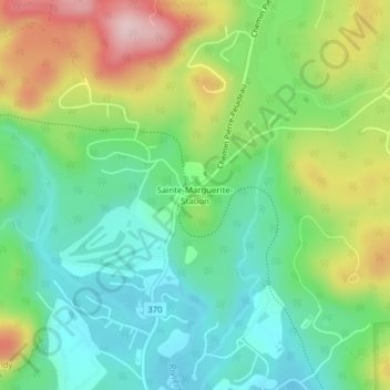
Sainte-Marguerite-Station topographic map
Interactive map
Click on the map to display elevation.
About this map
Name: Sainte-Marguerite-Station topographic map, elevation, terrain.
Average elevation: 290 m
Minimum elevation: 202 m
Maximum elevation: 448 m
Other topographic maps
Click on a map to view its topography, its elevation and its terrain.
Lac-Millette
Canada > Québec > Sainte-Adèle
Lac-Millette, Sainte-Adèle, Les Pays-d'en-Haut, Laurentides, Québec, J8B 2N7, Canada
Average elevation: 362 m
Lac-Renaud
Canada > Québec > Sainte-Adèle
Lac-Renaud, Sainte-Adèle, Les Pays-d'en-Haut, Laurentides, Québec, J0R 1R7, Canada
Average elevation: 340 m